The good, bad & ugly of the Garmin Zumo XT2: Full review


By John Milbank
Consumer Editor of Bennetts BikeSocial
04.08.2023


Date reviewed: June 2023 | Tested by: John Milbank | Price: £529.99 | garmin.com
UPDATED 4 August 2023. The Garmin Zumo XT2 on review here is a flagship dedicated motorcycle sat-nav, with some outstanding new features that’ll make many question whether using a phone as a GPS is still the best bet. There’s a lot to cover, and some glitches at the time of writing that you should be aware of, so I’ve spent the last few months using the Zumo XT2 on an R1250GS and a VFR800 to find out whether it’s worth the money…
Brilliant group-rides feature
Outstanding screen size and clarity
Brilliant live fuel pricing
Adventurous routing not as good as dedicated apps
Confusing web-based route planning software
Spoken direction volume could be louder over comms


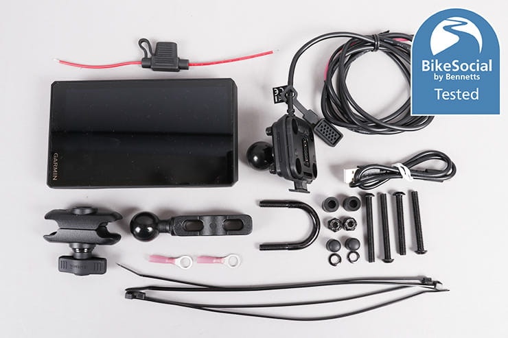
Features and mapping included
The Garmin Zumo XT2 includes street and topographic maps with 3D terrain covering Europe and the Middle East, while Africa (including Tracks4Africa), North and South America, Australia and New Zealand can all be downloaded for free from Garmin.com/express. Free map updates are included, along with many additional features…
Excellent quality 1280x720px 6” TFT screen
Group rides using free Tread app allow everyone to see each other on map
Live weather with an optional satellite view
Live traffic and closed roads
Easily switch between various map layers, including satellite and 3D terrain
Record rides with speed, distance and acceleration, and share via Tread app
Alerts of upcoming hazards (can be disabled)
Live petrol prices at filling stations
Adventurous Routing for twisty roads
Popular Paths for routes that other riders frequent
Trip Advisor and Michelin Green Guide recommendations
Up to three contacts notified if an accident is detected
Stream music direct from MP3s store on the XT2, or from your smartphone
MIL-STD-810 drop rating (typically 26 drops covering all faces, edges and corners from four feet)
Wireless updating
Compatible with Garmin InReach satellite comms
Compatible with Garmin PowerSwitch, for on-screen control of 12V accessories

The downloadable (direct from the XT2) satellite imagery can be a really helpful feature. This track’s just been clipped back, but I’ve found it really helpful when wandering off on some gentle byways.
Satellite imagery isn’t included on the Garmin XT2, but it’s free to download direct, either to the internal 32GB of storage, or your own microSD card up to 256GB. Annoyingly, the SD card can’t be formatted inside the Garmin, so you’ll need to make sure it’s FAT32 before inserting it.
The images can only be downloaded in chunks of up to 124.4 miles, each of which takes up 9.6GB after you’ve selected the centre point.
While you can specifically record your rides, all your trips can also found in ‘Unsaved tracks’ in the ‘Explore’ app of the Gamin, with data on speed, acceleration, elevation and the time being shown on the track, though – annoyingly – not the distance covered.
I haven’t been able to test the incident notification feature, but if the XT2 detects that something’s happened, you have 60 seconds to cancel a countdown timer. If that doesn’t work, your contacts will be notified. According to Garmin, “The device will send an automated text message with location information to the emergency contact when it detects an incident and the vehicle stops moving. This can help alert the contact to the rider’s situation if they are not able to call or send a message. This feature requires the device to be connected to the Tread app using Bluetooth technology and the user’s phone to have an active mobile data connection to send a message. If the user has not set up an emergency contact, the device automatically displays the nearest address or geographic coordinates, if available, when it detects an incident, which is helpful if the user needs to tell emergency personnel their location.”
Alternatively, incident notification can be paired with Garmin’s InReach technology, a subscription-based satellite system that allows contact from pretty much anywhere in the world.


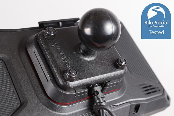
Note the three pins on the new XT2 bracket. I made an adaptor to mount the bracket to my GS with the RAM mount being used on the VFR.
Mounting to the bike
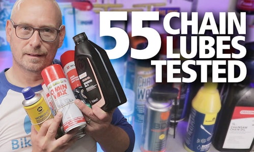
The Garmin Zumo XT2 includes a full RAM mount kit that should cover most bikes (and allowed me to mount on the VFR’s bars), though I fitted it to the screen brace on my R1250GS using the existing back plate, and a 3D-printed adaptor (download here) to go between the bracket and the brace.
The Zumo XT2 can be powered from any supply between 12V and 24V, and uses a much more compact cable than those of older Garmins. A fuse is included, though not attached to the wire – I didn’t use it as I powered the device from my Hex ezCAN (review here), which also powers it down when the ignition’s turned off.
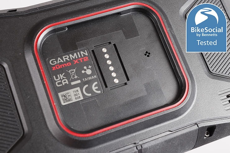
The new Garmin Zumo XT2 will fit the old Zumo XT cradle, ands accept 5V power from it, but the original XT will not fit the new XT2 cradle due to some small ridges on the new bracket. These are necessary as the new device takes a 12V feed, whereas the old one had a voltage regulator in the cable.
The mounting bracket is very secure, the XT2 clipping in and out easily with the push of a button, but it is vulnerable to being stolen. While looking for other options for this review, I did find this clever design that requires the bike’s key to be poked in to remove it, or there are various aftermarket options that range in price from about £40 to £200.
My only grumble with the mount is that the rubber bumper beneath the connectors flicks out easily, and while the sat-nav is still stable without it, I used a tiny amount of superglue to secure it.
Set-up and updating
When first firing up the Zumo XT2, it offers to connect to the free Garmin Tread app on your iOS or Android phone. It’s a pretty seamless process that then connects to your WiFi, followed by a headset if you want (I’m using a Cardo Packtalk Edge). It’s quick and easy, though there is no owner’s manual supplied – you have to either use the web app here, or download a PDF of the Zumo XT2 instructions here.
While I understand that printed manuals will be costly with so many languages to cover – especially for something this large (68 pages to read) – I really do miss being able to sit down and read a printed guide. There’s a lot to get to grips with here, but maybe it’s just a sign of my age.
Updating couldn’t be easier thanks to them all working over WiFi, which saves a lot of hassle. Large updates will depend on your WiFi speed and require power to the sat-nav, while smaller ones will often run automatically as the device powers down when you finish your ride at home, assuming it’s in range of your router.
Touchscreen sensitivity
The Garmin XT2 screen is very easy to use with any summer or winter gloves (as well as bare hands when you’re off the bike), making it far less hassle to use while riding than a mobile phone. Even with touchscreen-compatible gloves that work with a mobile phone, the ‘buttons’ are often very small on a mobile.

The map screen can be customised to show what you want by simply touching on each element, and while it’s not quite as efficient a use of space as TomTom’s design, I soon tailored it to have what I really wanted.
Display layout & clarity
A huge amount of information can be shown on the Garmin’s main map screen thanks to the detailed options and pop-out side bar, with everything from upcoming traffic, petrol stations, weather, trip data, elevation, group ride information, turns list and even a music player. To access it, just touch the icon at the bottom right of the screen. You can also touch on the bottom right panel to show direction, fuel range, temperature, time, or many other choices when you’re not on a route, along with arrival time, time to destination, distance etc when navigating.
The bottom left panel shows speed, and touching that brings up a much more detailed overview of arrival time, average speed, sunset, weather and pretty much everything you might want to see.
The Garmin is very customisable, but TomTom did show an incredible degree of efficiency in the layout of its new Rider 400 back in 2015, the relatively small 4.5 inch screen (which is no bigger on the Rider 550 now in 2023) managed to cram a huge amount of detail into a small space through very clever design, not least the progress bar that you could have running on the right hand side.
The TomTom bar shows upcoming speed cameras, petrol stations and other features, and is what I do wish was on the Garmin. Having spoken to an ex-TomTom employee, it’s not a copyright issue that sees this as so exclusive to the XT2’s competitor: it’s that apparently it’s an incredibly complicated piece of stand-alone software. And of course, it doesn’t fit the design of the Garmin eco system, which while updated and refined in the XT2, remains largely familiar to committed users of the brand. TomTom faced quite a backlash when it carried out the huge overhaul for the Rider 400.
The Garmin Zumo XT2 can be used in horizontal or vertical format, through you have to set the bracket where you want it when installing, unlike the TomTom that can be rotated at any point. I prefer the horizontal format, but haven’t had any issues with it changing orientation when leaning over in a ride.
UPDATE: Unfortunately the screen of the XT2 I had on review became unresponsive even after multiple reboots, however the unit was replaced under warranty.

Live traffic can plot a faster route, or at least prepare you for a delay, as long as the Tread app is connected on your smartphone.
With so many choices of what to display on the map, it can become cluttered, but the point of the Garmin is that it’s extremely customisable. I tend to use normal mapping when I’m on a typical navigated ride, switching to satellite view at times when I’m just exploring and want to see what’s around me. This can be extremely useful when I come across an unpaved road or byway, as I can check where it leads, and whether it’s likely to get beyond my abilities.
These are the options available to show on the map:
Foot trails
Michelin Scenic Roads
Popular Paths (Moto)
Paved trails
Unpaved Trails (unknown surface)
Gravel
Collections (your imported/saved routes)
Campsites
Unsaved Tracks
Contour Lines
3D Terrain
Traffic
Up ahead places (petrol stations, roadside services, trendy places)
The ‘Popular Paths’ are those most ridden by other motorcyclists using Garmin, and can clutter the map so I leave them turned off. I haven’t noticed any Michelin Scenic roads pop up (I may have missed them), but I leave them turned on.
Connections
UPDATED 27 JUNE 2023. After a 280 mile ride with the Garmin navigating to locations and tracking routes while connected to a Cardo Packtalk Edge (review here), the connections proved faultless, despite previously having several issues.
On this trip, I first tried the phone streaming direct to the intercom with the Garmin kept out of the loop. As that worked fine, I then streamed the music via the XT2, which gave control (I was using the DoubleTwist app on my phone) to the sat-nav via its app.
Spoken directions were played seamlessly over the music, and despite turning the systems on and off variously, they all stayed linked perfectly. The Tread app also reconnected itself every time, without fault.
I was also able to make a call to my wife via the Garmin’s built-in phone app with no problems.
Issues remain around connecting the BMW GS dash at the same time, but while I though this was likely down to the BMW Connected app, I heard from an owner of the XT2 who said that they were having the same problem with a Triumph and a Cardo Freecom 4+.
It’s not clear which device was causing the connection issues I had before, but the Garmin had been factory reset, and my phone automatically updates itself. I wasn’t aware of any updates deployed to the Cardo Packtalk at the time
Ultimately, it’s incredibly hard to cover every eventuality, especially when you consider we’re looking at multiple devices that all have their own updates rolling out. It’s why, if you do want to make the most of the tech available to you, it’s usually worth investing in the premium brands as they’ll be putting money into a development team that can keep on top of software updates.


Deviate from a downloaded GPX route – as I did here by taking a byway – and the Garmin will show a straight line back towards the track you should be on.
Waterproofing
UPDATE SEPTEMBER 2023: Garmin has now introduced a screen-lock feature with a firmware update, so if you do have an problems with rain, simply press and hold the power button on the rear, then select ‘screen lock’. Deactivating it is simply a matter of tapping the power button again.
Since motorcycle sat-navs switched from touch-screens (with a film over the top to sense presses, while also reducing clarity) to capacitive screens like those used on mobile phones, they’ve become somewhat susceptible to rain droplets activating them.
A motorcycle GPS screen – like those fitted to the current TomTom and Garmin products – is even more sensitive than a phone as it must be able to sense your finger through even winter gloves (which the XT2 does fine). The problem comes when rain hits the screen at just the right angle and triggers a ‘button’ (this is also a problem on phones though).
In my testing, the more upright the Garmin is mounted, the less susceptible it is to rain affecting it. Equally of course, if it’s tucked behind a screen (and turbulence doesn’t blow droplets back onto it), it’s unlikely to suffer any issues.
Garmin could cure this entirely with a screen lock – for instance, pressing and releasing the power button on the rear could put the Zumo XT2 to sleep, while holding it for one second could lock or unlock the screen. Pressing for three seconds could shut it down completely. Or an option to lock screen could appear when the power button is pressed, like on some other Garmin outdoor devices.
The Garmin Zumo XT2 is IPX7 rated, meaning it’s not been rated for dust resistance (the X), but that it could be submerged to 1m for 30 minutes. So it’s waterproof, and as long as the silicone covers on the base are kept closed, dust won’t be a problem.
Those covers work well, but if pulled awkwardly they can pop out, and refitting them is a fiddly job that requires a small screwdriver, so don’t pull too enthusiastically on them.
Ease of route planning
The Garmin Zumo XT2 finds satellites extremely quickly, even when sat in the house, and planning a route can be as simple as entering an address or even typing a business name into the search bar. It’s not perfect: Chris Walker Kawasaki in Grantham shows up thanks to being on Trip Advisor, but Motocom (one of the leading motorcycle PR agencies I was going to for a meeting) isn’t, so for that I needed to use my phone to Google the address. It’s a shame that, given the data connection already established, the Garmin can’t perform wider searches via your mobile.
But that’s nit-picking, and I can’t complain about the wealth of options when it comes to telling the XT2 where you want to ride, with the fact that when selecting a destination, the option is immediately there to simply ‘Go’, to get more info on the destination – including its phone number in some cases (though sadly not opening times for businesses) and nearby parking, as well as the weather there – or to choose one of four levels of adventurous routing to get there.


Garmin’s Adventurous Routing is good, but Calimoto has it beaten. On this ride using the most winding settings, the sat-nav wanted to use the boring A6, while Calimoto picked up the lovely route running parallel with it.
You can also plan a round trip from any location – including where you currently are – based on time, distance, duration or destination, in any direction or your choice, and with four levels of winding road. Impressively, it does come up with different routes even if you use the same variables, but I’ve found they still aren’t as good as Calimoto, at least for my riding style. Even on ‘maximum winding’, there are too many main roads and cuts through city centres, whereas Calimoto gives me real back-roads. I’ve also started experimenting with Kurviger, which has an Android app available as a Beta.
It is possible to export a route from Calimoto into the Garmin Tread using the ‘Explore library’ as this syncs with the XT2, but it’s not an ideal method and loses any replanning if wandering off route, though a straight line back to the route is shown on the GPS screen.

The Tread app itself can be used to plan routes fairly easily by simply touching points on the map or searching for locations. These can then be synced with the XT2 wirelessly and quickly.
If you’re planning a particularly long route – and especially if you use the adventurous routing option – the app can get quite slow even on my Pixel 7 Pro, but it’s great to be able to plan on the phone before a big trip. You can also plan routes on the Zumo XT2 itself, which is reasonably quick in its calculation.
Besides importing GPX files from other devices (or even importing the Bennetts BikeSocial test route here), you can of course use Garmin Basecamp, export your plans, then import them into the Garmin Explore website.
The Explore website itself can be used to plan waypoints, but I found it complicated and unintuitive. It’ll sync with your XT2 once that’s been added to the website, and can be loaded as a route, but attempting to change it to an adventurous route on the XT2 appears to strip out all but the start and finish waypoints.
I’m no luddite, having taught myself coding for Arduino, built a motion-controlled camera rig, and more recently learned CAD using Fusion360, but while I’m sure that seasoned Garmin users have found a way of incorporating the external software into their trip planning routine, as it seems so confusing to me and I can do all I want with the device itself, I just don’t tend to use it.
Basecamp is notoriously hard to use, and sadly the Explore website isn’t a great leap forward, for now at least. If you’ve got to grips with it, do get in touch on the Bennetts BikeSocial Facebook page, and I’ll keep this review updated.

It might smell like one, but contrary to what the Garmin says on the map, there’s no toilet here.
I’ve had no issues with the accuracy of the Garmin Zumo XT2, which appears to get an excellent hold on satellites very quickly. Riding off-road also shows the bike on the satellite image map exactly where it really is.
Following the line is intuitive, and upcoming turns are clearly shown at the top of the screen. Main road exits are also illustrated with a pop-up on the right, which makes it really clear what lane to use. As a means of getting where you want to be, I can’t fault the Garmin, and while Google maps can do a great job too, the additional options – and especially the ease of use with gloves one – can make a dedicated sat-nav like the XT2 worth the investment.
With the Garmin connected to a quality intercom (I’ve tested it with both Cardo and Sena devices), spoken route direction clarity is outstanding if set to the higher ‘A2DP’ standard. The level of detail that’s given beyond speaking road names is also very impressive, for instance ‘Turn left at the stop sign’ or ‘Turn right at the traffic lights onto Angel street’.
I’m also impressed with the accuracy of the XT2 when it comes to identifying closed roads, though this of course rely on being connected to your smartphone for data.
My only issue with the navigation is that spoken directions (and speed camera warnings) could do with being louder when played over Bluetooth – I find that at high speed, the wind noise can drown them out a little too much.

A ride summary is shown at the end of navigating a route.
As long as your phone’s connected, traffic delays are alerted in the side bar and avoided by default, but this automatic route changing can be disabled.
Clicking on the vehicle on the map immediately takes you to a ‘Where Am I?’ page, with a clear display of your coordinates, the nearest junction, nearest address and buttons for hospitals, police stations and petrol stations. You can also select ‘directions to me’ from the top right menu on that page – put in where you want the Garmin to plot from, and it then gives turn by turn directions as a list that could be read out to someone trying to get to you.


While we’ve all got used to looking for places to go on our smartphones, the integration of Tripadvisor into the Zumo XT2 does allow you to easily search for hotels, things to do, or restaurants, each with its own sub-categories. ‘Restaurants’, for instance, gives the option to browse by style (eg Indian, Italian, Chinese etc), or from barbeque and breakfast to pizza and steakhouse. Selecting ‘Coffee and Tea’ brings up results within up to a 25 mile radius, sorted by popularity, nearest, or within 5, 10 or 25 miles. It’s a great way to find somewhere to stop, and with a little use becomes a much-appreciated feature of the Garmin, if not something you can’t do with your phone. While you shouldn’t look for places while riding, it could mean you can find somewhere very quickly when pulled over, without having to faff about getting your gloves off, digging out your phone and starting a search.
The Michelin Green Guide has some interesting points of interest, and its star ratings indicate whether a location is ‘Interesting’ with one star, ‘Worth a detour’ with two stars or ‘Worth a journey’ with three stars. London’s Natural History Museum only earns two stars, which seems a bit low, though the city of Peterborough has no stars, which I wouldn’t argue so much with. Its cathedral gets two stars, and that is pretty impressive.
The search isn’t perfect – looking for a ‘motorcycle shop’, ‘motorbike shop’, ‘motorcycle dealer’, ‘motorcycle garage’ or ‘motorcycle mechanic’ doesn't deliver local dealers. That'd be helpful, but again, Google will help if you need it. Searching for ‘Webbs’, the Peterborough Yamaha dealer appeared though, showing in the info as in a section called ‘Everyday Life: Motorcycle Shop’ (despite that not being listed in the Categories), so it’s strange that it doesn't come up when looking for ‘Motorcycle Shop’. It seems odd not to group motorcycle dealers and mechanics, in case someone needs a mechanic while on a big trip.
However, if you go to the search page, then click ‘Categories’, then ‘Everyday Life’, then ‘Vehicle Services’, then ‘Vehicle Repair & Parts’, you do get all the mechanics nearby. It’d be handy to be able to filter to a motorcycle-specific shop, but it’s a start, even if putting in the word ‘motorcycle’ only filters to locations with that word in their name, missing out on main dealers like Webbs, or specialists like BSD in Peterborough for instance.
There are other niggles with the navigation: laybys often show up as toilets, and while many might smell like it, there’s rarely an official loo there.
The ‘up ahead’ tab is also useful, but I’ve found it occasionally displays things (even petrol stations) that, when clicked don’t appear to work. One example was Ampthill Brewery towards the end of the A421 heading west, which came up as a place of interest yet disappeared when I clicked on it to set a route. When I stopped and Googled it, the place was marked as permanently closed. Perhaps there’s a disparity in some of the mapping.
Ultimately, the Garmin Zumo XT2 has some superb features that are worth a good few quiet hours sat on the sofa to explore, but there is still room for improvement in the user experience.

There’s no trace of Tilton Garage on Google or when visiting there. Houghton Garage does exist, as do the two below in this pic, but they’re more obvious thanks to the excellent live pricing when connected to the Tread app.
Finding fuel
Garmin has kept its fuel tracking feature, which can help you navigate based on expected tank range. This could be handy when overlanding, but you must of course manually reset the tank when filling up. It’s an impressive feature that many will like, but the progress bar showing upcoming fuel stations on the TomTom Rider is far easier to use – and more reliable – for my use.
Reliability was a problem with the last Garmin I reviewed, and I’m disappointed to see that some petrol stations listed on the Zumo XT2 still turn out to be long out of use (even completely different buildings in some cases) when I arrive at them.
But, offsetting that is an absolutely brilliant feature, and one that doesn’t demand any subscription fees: the live pricing that’s shown on screen when the Tread app is connected. Not only can this help you quickly find the cheapest fuel nearby, and quickly navigate to it, it’s confirmation that it’s a working garage. Not all stations without a price are closed, but it’s a handy way to pick one if the choice is there.
Upcoming petrol stations can be shown in the pop-up panel when navigating, or you can search for one close by at any point, adding it to your current route.
Speed camera notifications
The Garmin Zumo XT2 has a lot of options, including the ability to alert of upcoming speed limit reductions, mobile cameras and if you’re speeding by a set threshold in or out of town.
Alerts can be audible, though if they’re turning off music that you have playing through your intercom, they can get frustratingly frequent, particularly in city centres.
My only real grumble is, once again, the lack of a precedent set by TomTom. While the Garmin will alert you of average speed cameras, its rival takes things a huge step further by actually displaying the average speed you’ve been travelling while within the zone. It’s a clever addition to the progress bar, and another thing I miss from that ecosystem.
Adapting your route / detours
Ride off course and the Zumo XT2 recalculates quickly, its Android-based internals clearly having a decent amount of grunt.
A planned route can be altered by touching on the map and selecting ‘shape route’, while detours can be made by pressing the pop-up panel icon in the bottom right of the display, then selecting ‘Edit Route’, where you can add a shaping point to the route, detour by distance (with 0.5, 1, 2, 5 and 10 mile options), or detour by road, which presents you with a list of the upcoming roads on your journey, in order.

It’s well worth spending some quiet time with the Garmin to get used to all the features, many of which are quite buried away (though easy to access once you know where to look).
Garmin Group Rides
A huge benefit to the new Garmin Zumo XT2 and its compatibility with the Tread app is ‘Group Rides’, which show the location on your map of someone who’s also got an XT2 or one of the car/ATV-focussed Garmin Tread GPS range. You can now easily keep track of others in your group, or find someone you’ve lost.
But it also works with someone who simply has the app on their phone. It’s very quick and easy to create a group ride on the phone app of the XT2 itself, then all other riders can join by entering the six-digit code that’s generated, or by scanning the QR code if they’re at the same location.
This is incredibly slick, with the other rider’s names shown on the sidebar (which can be closed), their distance away and their direction of travel. The names have a coloured bar next to them that matches an arrow on the map, which switches to a dot when the rider stops moving.
While the other riders can disappear off the map view you’re in, touching the navigation icon cycles between 3D nav view, top-down nav, and zoomed out to accommodate all riders.
The fact that this can be used by any other rider as long as they have the Tread app and have created a free account is outstanding. A rider could attach their phone to the bike then use the app to follow the other riders. Of course, while it displays full mapping (including satellite views), this isn’t a fully-fledged nav system in itself, and you can’t share routes to a Garmin Explore account without registering a Garmin device.
To achieve this on the Zumo XT, both riders needed the sat-navs and additional hardware, so while the XT2 is a big jump in price, the Group Ride Tracker required for the original Zumo XT added another £180. This radio transmitter/receiver will be an option on the XT2 for those who need connectivity where there’s no phone coverage, but for the average rider it’ll be unnecessary.
The potential of the Tread app is huge, whether it’s one rider leading a group who all have the Tread app on their phones in order to stay in contact, a rider who’s partner is meeting them in their car and can both see each-other’s location, or even using it on a walk to keep track of the kids as they run off and explore.
Update 4 August 2023: During initial testing, the Garmin wouldn’t maintain the position of the other rider on screen, but a recent update has cured this issue and it’s now working perfectly. The Group Rides feature also maintains its mapping even after devices have been switched off or moved out of range: only when a rider chooses to leave the group will it disconnect.

Even with both ‘riders’ in the same car, and both Tread apps – on separate accounts – tracking perfectly, the second rider soon drops off the Garmin’s map. In this pic you can see where it’s stopped on the XT2’s map, but is still tracking on the phone that’s paired to it, supplying the data.
Battery life
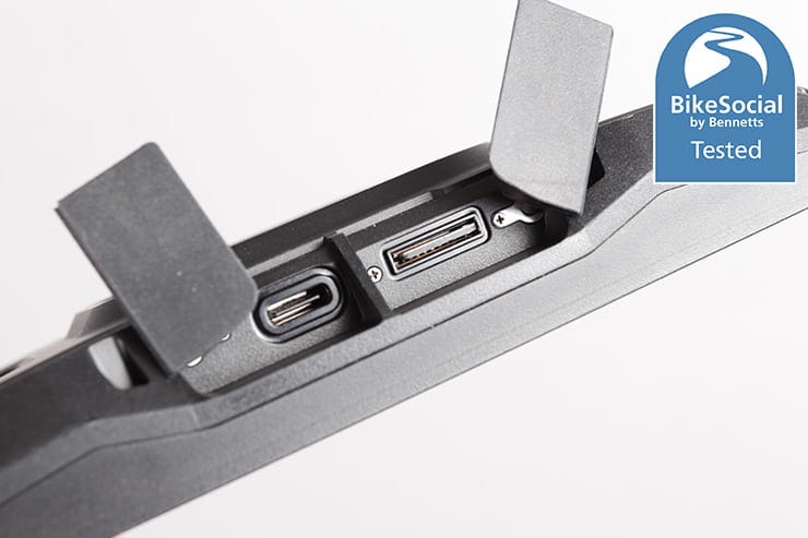
The Garmin Zumo XT2 has a much-improved internal battery compared to the Garmin 396 LMT-S I reviewed a while back. Even when downloading satellite image data over WiFi while using the device to plan routes and check out other features, the internal battery had plenty of life in it. It’s still obviously best to hard-wire it on the bike, but if it’s fully charged, it might get you out of trouble on a bike without the cradle, maybe tucked into the top of a tank-bag. As it can be powered by USB-C though, there’s little reason to not have a supply to it during use.
During my testing with navigation running and also planning routes, it was four and a half hours before I got a low battery warning. Only after six hours and forty minutes did it shut down entirely.
The XT2 can be charged via USB-C, which is surprisingly slow even with a powerful charger, but there’s no indication of what battery level it’s reached while a supply’s connected.
Car use
The Garmin Zumo XT2 can of course be used as an in-car GPS, but with no car mount included (it’s a £24.99 option), Garmin has probably decided that many drivers are using Android Auto or Apple Car Play, while those with older motors like me tend to use Google maps.

Closed roads are shown clearly on the XT2 with the Tread app connected.
Garmin Zumo XT vs Garmin Zumo XT2
At the time of reviewing the Garmin Zumo XT2, the original Zumo XT is still available, but stock is limited.
I’m unable to compare the two directly, but I did get my hands on an original XT to give a rough idea of the differences….
The slightly smaller 5.5” (measured across opposite corners) TFT screen isn’t a massive difference to the 6” offered by the XT2, and both are the same 1280x720px resolution, but they do look quite different. Whether it’s simply down to the colour palette used, the XT2’s mapping looks clearer and better defined than the older model when viewed side-by-side, with a backlight that appears to be brighter and more white.
Both the XT2 and the XT seemed pretty much as responsive as each other, and the XT2’s menu refresh isn’t alien-looking to hardcore Garmin users, but it does look a little cleaner and more modern thanks to more restrained use of colour in the icons.
The XT2 charges via a USB-C port, while the XT has the older mini-USB, which could mean one less cable to carry on a trip. I doubt that extra weight will upset even the most lightweight overlander, but it’s worth mentioning.
The biggest difference between the Gamin Zumo XT1 and the Zumo XT2 is the compatibility of the Tread app with the newer device, which brings with it – most notably – the Group Rides feature. Routes can be planned in the Tread app too, then shared easily to the Zumo thanks to integration of ‘Explore’ in the app. It appears Garmin is trying to streamline its external software.
With many of the features being generally very similar, the Garmin Zumo XT can represent good value for money, but if you can afford it, the XT2 is a significant step forwards, and the Group Ride integration could be worth the additional cost to many.

While not everyone’s cup of tea, it’s backroads like this that I really enjoy.
Four alternatives to the Garmin XT2
The Garmin Zumo XT2 is very much a flagship device when it comes to motorcycle navigation, but here are some other options…
The older Garmin Zumo XT could be a good choice if you can still find one, but the new model does have some significant upgrades.
The TomTom Rider 550 was my favourite dedicated motorcycle sat-nav for a long time, but the Zumo XT makes it look a bit long in the tooth now. Still, it has some great features and is very clean, simple and intuitive to use, plus can be found for less than £300 now. Check out the full review of the TomTom Rider 550 here.
The Carpe Iter v4B tablet reviewed here is a tough device that can be mounted securely to the bike to provide outstanding clarity thanks to its incredibly bright screen. With the option to use any Android software, including the excellent Locus Map (which it comes with), OsmAnd and many others (including Calimoto and of course Google Maps), investing in this can seriously change your rides due to the clear, uncluttered view. You can even use real Ordnance Survey maps through Locus Map if you want.
Using your phone on the bike can be a good, cheap solution; for getting from A to B with as little fuss as possible, Google maps does a great job. If you want some of the best winding roads, Calimoto is well worth the money (you can try it for free), or the new Kurviger app on Android is worth a look. However, phones can be very fiddly to use on the bike, and there’s the possibility of them getting damaged due to vibration. I’ve used SP Connect with great success, or Quad Lock is another option, not to mention others from the likes of Oxford Products and Peak Design for instance.
You can even control many of your apps on a phone or tablet using a bar-mounted Bluetooth controller from Carpe Iter (I bought myself the excellent Adventure Control, reviewed here and have since also reviewed the BMW-specific controller the company offers, reviewed here), which allows panning and zooming in a wide range of software from Google maps to Locus and many more.
Another option is the Drive Map Dashboard, or DMD2 software, though it's primarily focussed on off-road riders. This launcher can group the apps you want together, as well as providing a huge amount of other data, and of course it can be used with controllers. There’s currently full topographic mapping available via subscription on DMD2, and there’s a new version under development with turn-by-turn guidance.
These are just four of many alternatives – you can find all the motorcycle sat-navs we’ve tested here and be sure to regularly check for the discounts available through Bikesocial membership.

I love discovering roads that are new to me, and a sat-nav can really help with that.
Garmin Zumo XT2 review: Verdict
I’m obsessed with trying to give the most detailed reviews possible, yet I do feel I’ve only scratched the surface of some of the features and benefits of the Garmin Zumo XT2, despite this being a ridiculously long article.
As a sat-nav designed for motorcycle use, the XT2 is much easier to operate with gloves on than a mobile phone, and I love having its large, clear mapping running so I can see what’s around me. If I turn on the satellite imaging, it even helps in checking out whether a byway’s likely to get too rough for my poor off-road skills.
Sometimes I like to just head off in a certain direction, using the Trip Data sidebar to point me on my way with its heading display (though a compass graphic would be better than letters representing N, S, E and W).
There are touches that TomTom does well, which I miss on the Zumo XT2 – most notably the progress bar on the side – but I was very impressed by the Tread app’s Group Rides feature, and the potential this has for me to use the sat-nav with anyone else, regardless of what GPS they’re using. Or indeed if they’re not using one at all and only have the free Tread app.
There’s no denying that the Garmin Zumo XT2 is an expensive device, but the large, clear screen, ease of use compared to fumbling with the small ‘buttons’ on a phone, the huge customisability and the live fuel pricing mean it could be an excellent choice for many riders
Ultimately, the Zumo XT2 has proven the very real benefits of a dedicated motorcycle sat-nav thanks to some outstanding features.
If you have any remaining questions about this device, you can access the Garmin Zumo XT2 owner’s manual here as a web app, or here as a downloadable PDF. You can also join the Bennetts BikeSocial Facebook page to ask any more questions, and to get the help of thousands of like-minded riders and industry experts.