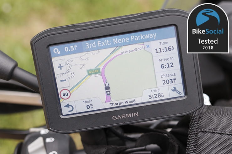
Tested: Garmin 396 / 346 LMT-S sat-nav review


By John Milbank
Consumer Editor of Bennetts BikeSocial
12.06.2018


Date reviewed: June 2018 | Tested by: John Milbank | Price: £349.99 | https://buy.garmin.com
Garmin’s new 396 LMT-S and 346 LMT-S are rugged sat-navs with a 4.3” display designed for motorcycle use, with features including WiFi updating, adventurous routing, live traffic, speed cameras and weather, as well as notifications from your phone.
I’ve been using the 396 over many journeys – it costs £50 more than the 346, but comes with mapping of full Europe rather than just Western Europe, and includes a car mount…
Features and mapping included
The Zumo 396 LMT-S includes ‘lifetime’ maps giving full coverage of Europe – this means that for the ‘useful life of the device’, and as long as you update it at least every two years, the maps that came with your device will be updated for free. If you buy any further maps, these will be a one-off purchase and won’t include free updates (worth bearing in mind if you choose the cheaper 346, which has Western Europe only), or if you’re planning to use it in elsewhere in the world.
A Ram mount system is included for fitting to your bike’s handlebars, as well as a bracket with suction cup for your car.
Features include:
Live traffic data
Media player
Notifications from your smartphone
Make and receive calls from your phone when connected to a Bluetooth headset
Live weather throughout your route
‘Adventurous routing’ for journeys taking in curvy, hilly roads and avoiding highways
Switchable alerts when approaching sharp curves, speed cameras, rail and animal crossings, schools and slower traffic
Incident notification, to alert the contact of your choice in the event of a crash by sending them a link to your location (requires smartphone connection)
Switchable fatigue warnings that offer you suggested stops nearby
Ability to avoid specific areas and roads when planning routes
Fuel notifications and route planning based on your predicted fuel economy
Trip Advisor app built in can give overall ratings of nearby restaurants, hotels and things to do
Foursquare app for a list of restaurants and things to do nearby


The supplied mounting kit allows you to fit the Garmin to practically any bike, though the wiring can be a little bit time consuming to install
Mounting to the bike
A Ram mount kit is supplied, which should allow the Garmin to be fitted to pretty well any bike. The power cable needs to be run through your machine before screwing into the mount, and there aren’t any ring connectors on the cable to fit to your battery terminals, so you’ll need to add some yourself if not wiring into an ignition-switched supply.
Near the supply end of the cable is a fuse, and a box that steps the 12V battery power down to 5V – it’s not too bulky, but you do need to find space for it. There’s also a suppressor on the cable, which adds a little to the bulk. Fitting requires a small PH0 screwdriver and a PH2, as well as 7mm and 11mm spanners.
It’s a shame Garmin doesn’t offer a locking bracket for the 396, but an aftermarket manufacturer is sure to produce one – it gives peace of mind when you pop in to pay for fuel.

Connecting to a smartphone gives live traffic and many other features for very little data use
Set-up and updating
Setting up and updating is very easy thanks to the 396 LMT-S having WiFi built in. I turned it on, connected it to my wireless router and plugged it into a USB charger to have everything update itself – a lot less hassle and much quicker than downloading maps to the computer, then having to upload them to the device.
A smartphone app for iOS or Android is required to display to the traffic data and weather. You can register and update the sat-nav using the app, but I found it just as easy on the device itself.

Being able to control music from the device is a great feature
Touchscreen sensitivity
The traditional touch screen is responsive regardless of what gloves you’re wearing. Some of the buttons (like the one to close notification windows) can be a little small, but you soon develop a deft touch for the right place.
Like other devices, many of the menu items can also be scrolled, so you need to rest your hand on the device as you click, to prevent your finger shaking and moving the selection, rather than activating it.

The display is easy to read in most lighting conditions
Display layout & clarity
The Garmin uses the same layout as has been on its devices for many years – much of the information can be customised, and the left sidebar can display a range of different options, including elevation, traffic and other items like fuel ahead, trip data, weather, phone and the media player.
Being a traditional touch-screen, rather than the capacitive screen used in your smartphone, the display lacks a little contrast. On the road, it needs to be at full brightness, but then it can be easily read in most conditions; only with the sun behind you on a clear day does it wash out fully.
The text is clear and easy to read, even when wearing my long-distance glasses (which see me struggle close-up with some other devices), and much of the displayed information can be customised.
Waterproofing
The Garmin is well sealed from the weather, and never caused me any issues while riding in the rain. The screen is completely unaffected by water, regardless of how heavy it is, so you can confidently use the 396 in all weathers.

Ease of route planning
Destinations are easily programmed, and the keyboard can be displayed with small keys across one screen, or with two pages showing larger keys. Choosing a route is quick and easy, though it won’t programme until there are satellites – this is irritating if trying to set the device up indoors before leaving, and especially so at difficult locations like airport car parks. Once satellites are found, the route will be planned, but other devices will plan a route based on the last known location, adapting it as necessary when connection is re-established, which also gives you a chance to modify it if you need to.
Switching to ‘GPS simulation’ in options allows you to fully plan a route, but this turns off GPS, so you need to go back into options to switch it back on before you ride. You can however set one up by going to the ‘Trip Planner’ app, where you can save planned routes.

The ‘apps’ menu gives access to a huge range of options
The Garmin recognises when it’s in a bike mount, automatically selecting the bike profile – car, motorcycle and off-road profiles are built in, which affect the default route planning, map view, tools displayed, avoidances and off-route recalculation modes. Modes can also be changed by clicking the small vehicle icon at the top of the main menu screen.
By default, routes can be planned as fastest, shortest, ‘off-road’ (which plots a straight line to the destination, to keep you heading the right way – potentially great if you want to explore on the way to a destination) and ‘Adventurous’. The latter can be programmed to use one of three levels of bend twistiness, altitude and to avoid major motorways. Like the ‘plan a thrill’ option on TomTom’s Rider, this can give hugely enjoyable rides, though be prepared for some narrow and sometimes bumpy back roads. As an adventure bike rider, I love it, but a sportsbiker looking for fast roads might be disappointed.

Adventurous routing offers up some great rides if you like exploring back roads
It’s a shame you can’t change the adventurous options while planning a route to see the effect they’ll make (you have to go back into the setup menu to change them), but the results are great – I used it to transform a 187mile ride that would have taken three and a half hours on main roads, to a brilliant back-road blast of 207miles in six and a half hours.
Typically, I prefer to have my device set to fastest route – even on the bike – because my day-to-day usage often involves getting across the country to meetings. Selecting Adventurous routing requires it turning on in the menu, so there’s a risk of forgetting to disable it later, though an alternative is to plan a route, then open it in the ‘Trip Planner’ app on the device, before switching it to an Adventurous route then saving it. It’s just a shame it’s not as intuitive as TomTom’s system, which gives similar results with its own dedicated menu.
You can also have the device suggest attractions for your route – it’s a nice touch, though of course the results won’t always be of interest – while ‘Round trip’ planning allows you to go for a ride from the location of your choice, programming by distance, duration or a destination – a neat feature for when you have some spare time and fancy a blast.

Planning a route is pretty fast, as is recalculation when you veer off course – it’s quicker than the TomTom Rider up to the recent 450, though not as quick as the new 500/550.
Following directions is easy, with plenty of clear information in the top bar relating to the upcoming turn, a clear map (which can be adjusted for detail), and the option of illustrations of major motorway junctions, making it easier to understand which lane to be in. Positioning accuracy is of course very good, and lag (for instance when leaving roundabouts) is minimal.
A major benefit of modern sat-navs connecting to smartphones is that they’re able to use the device’s data (it’s only a very small amount) to get the latest traffic updates; this can prevent you getting stuck in heavy traffic – for instance where filtering just isn’t possible – and also navigate around closed roads. Disappointingly though, the 396 missed two closed roads on one 200mile ride. It’s easy to click ‘change route’ in the sidebar options in order to find an alternative, but a TomTom I also had running did display them.

The 396 failed to identify this closed road on one ride, despite being connected to my phone
The smartphone connection runs through an app on your phone – I found this rather inconsistent on an iPhone SE running iOS 11.3.1, not always connecting automatically, and also dropping the connection altogether several times during long journeys, then not reconnecting; this can be a real annoyance if you don’t realise it’s done it, as it could miss traffic problems along the route.

The traffic up ahead sidebar shows all is clear if the data connection has dropped out – after turning Bluetooth off and on again, it showed a delay just two miles away
If you run off course on an ‘Adventurous route’, the Garmin will quickly recalculate how to get back onto it – this is much faster than the ‘Winding routes’ system of TomTom’s 450 and previous models, which recalculate the route from scratch and can take several minutes. However, when I took a wrong turn and found myself on a dual carriageway, rather than look for the next exit, the Garmin simply displayed the message ‘Cannot calculate route’ and stopped navigation. This happened twice more while riding off course in the New Forest, where I had to access the route planner to start it again. As I like to explore areas when something interests me, this is a bit disappointing.
While they can be disabled, many features rely on pop-ups, which can be a little distracting, and can involve more interaction with the device while you ride – the best bet will be to work out which you want to use (like the take a break feature, which suggests nearby places to stop), and enable them only.
Finding fuel
Fuel tracking recognises when the device is in the bike mount, and will track the distance covered, suggesting fuel stops based on the distance you tell it that can be covered per tank. When you stop, it will also ask if you’ve filled up – click yes and it’ll reset the tank. This is potentially an excellent feature if you’re riding in the deepest wilds, where fuel stops might be few and far between, though it’s at its most useful when you’re travelling at a reasonably consistent pace – I’ve seen my bike give 71mpg on one day, 58mpg the other, so set it up based on your lowest expected economy.

Pop-ups can be handy in many cases, but irritating too…
The device can be a bit eager to ask if you’ve reset or if you need to find a filling station – at one point I clicked on the fuel warning notification and selected a filling station nearby… When I stopped to fill up, it warned me again that fuel was low and asked if I wanted to search for fuel again. Also, if you run off course, every time the Garmin recalculates, a pop-up window covers the mapping, asking if you want to search for a filling station; this soon gets annoying.
Unfortunately, the Garmin database of active filling stations doesn’t appear quite as up to date as it could be – on a 200mile ride I passed one location that the device said was a filling station, but hasn’t been for many years. Later in the day – when I urgently needed fuel – the 396 took me to a corner shop that also had no petrol pumps (and didn’t show any sign of having had them for a long time).

Filling stations can be searched on a map or by a list
You find filling stations as a list (showing distances) or on a map, so getting to them is easy, and you can also show the ‘up ahead’ sidebar when riding, which will display three items that are coming up nearby, from a choice of speed camera, motorcycle locations (dealers etc), restaurants, petrol stations, banks and cashpoints, attractions, parking, roadside services and lodging. See one you want and you can click on it to be taken to a menu that will allow you to add it to your route. Having used the scrolling sidebar of the TomTom though – which constantly lets you know when the next two fuel stops are available on your route – it doesn’t feel quite as elegant as it could for the average rider.
Speed camera notifications
If you’re going too fast, the speed display will glow red, while upcoming speed cameras are notified with an icon on the map. As you approach them, the display’s top bar will show a warning, though the device doesn’t show your average speed while riding (or driving) through sets of average speed cameras.
Adapting your route / detours
Tapping on the map allows you to see an overview of the route, or enter ‘route shaping,’ which lets you zoom in and add waypoints to your planned destination; if you want to add specific locations through search, you can do this by going back to the menu screen, finding the location and adding it to your route.
Alternative routes are suggested via a pop-up window when traffic is ahead – it’s a useful system, but takes a few clicks through small menus to get to the alternative. At the time of writing, a small glitch gave incorrect time information on the alternative route menu, though it worked fine when programmed.
Did you know? Having live traffic data is brilliant when driving a car, but it can also be very useful on a bike. For instance, knowing of seriously heavy traffic on a motorway can give you time to get off the road, rather than end up trapped at the front of the queue after an accident has shut the road.
Additional features
Smart notifications can be displayed while riding – these can include alerts of emails, missed calls, SMS, WhatsApp, Facebook Messenger and other notifications that would appear on your smartphone’s screen. You can select what categories of alerts are shown, or turn them off altogether, and while some might not want them, they’re a useful addition and very comprehensive, even letting me know when the Blink security system at home had armed.
When a notification comes through, it slides in on the right of the screen – click it and it’ll be read out through the built-in speaker, or through your Bluetooth intercom. It very useful if you want to stay connected, though the notifications don’t disappear after a period – you have to click on the small button to dismiss them. You can access previous notifications through the Apps menu, though too often the Bluetooth connection drops out and needs forcing to reconnect.

The weather along your route is a genius feature
• One great extra that can be accessed via the side panel is weather – as long as the Garmin is connected to your smartphone, it’ll show you the expected weather at three points along your planned route – great if you need to know when to put your waterproofs on, or are simply deciding where to go next.
• Help is built into some of the menus, which is a neat touch to guide new users through the device.
• The Trip Advisor app is slow to search, but a handy way of finding things to do nearby (though it’s not as comprehensive as the website). I prefer to use my phone for things like this, but the data is embedded in the Garmin, so you can still use it without having a data signal. Unfortunately you can’t click through to read any reviews, but if your smartphone’s connected, you can see the weather at the location now and for the next five days.

The Trip Advisor app works without a connection to your phone
• The new incident notification feature is designed to send a text message with your location to a contact in the event of an accident. It won’t send a message if you don’t have satellite coverage, and will display a warning for 60 seconds before sending the SMS via your phone, though it’s not clever enough to register any speed, so can’t tell the difference between dropping the device onto a desk, or an actual crash. During my testing, the messages failed to send, asking me to confirm my phone was connected (it was).
• The media player is a great extra feature – unlike its competitors, the Garmin can directly control playlists and tracks from your smartphone via Bluetooth – or music that you copy onto a micro SD card and install in the device – to play through on your intercom.
• The Trip Planner app allows you to modify your routes, change the order of stops and save them for the future – it’s not as quick to access as it could be, but it creates a useful place to sort and organise your journeys.
• When connected to your phone, you can invite people to watch your route using the LiveTrack app – they’ll be sent a link via email to watch online, and an alert on the menu will remind you that it’s recording – it’s a neat feature if you want to share a big adventure, and you can still see the journey after it’s completed, with graphs of elevation and speed available, though it does depend on having a stable connection through your smartphone, or the tracking will stop.
• Using the app on the 396, you can also share routes to other Garmin devices using Bluetooth, or download a GPX to your smartphone, which can then be sent via email, AirDrop, SMS etc.
Battery life
The fully-charged battery has more than enough power for plotting routes, but after about an hour and a half, the screen reduces to 40% brightness (too dim for outside use), before shutting down after a total of around three hours. The Garmin 396 would be fine for short rides without a powered cradle, but anything more will need the loom wiring in.
Car use
The 396 LMT-S includes a car bracket and cigarette-lighter power supply. Given the price compared to the competition, this is a great addition, though it is only very basic – the cable has to be plugged in beneath the rubber flap on the back of the device before clipping into place; it’s not as convenient as a bracket with its own power connection built in.
The built-in speaker is clear and loud enough for navigation in the car, and if you use adventurous routing on the bike, the Garmin will recognise when it’s plugged into the car charger (or any other USB supply) and ask if you want to switch to car mode, which can default to fastest route planning for instance.
When in car mode, any smart notifications from your phone can be read on the screen by clicking the ‘passenger’ button (on the bike, they can only be spoken to you through a Bluetooth intercom). It’s potentially useful, but I think it’s a little too tempting for easily-distracted drivers.

Verdict
The Garmin is a very full-featured motorcycle sat-nav; you can customise many of the display options, and it’s got a lot of extra bells and whistles, though how valuable you find these is something only you can decide.
While I do love the ability to see the weather along my route and being able to control my music, I don’t tend to use most of the other apps, like Foursquare or Trip Advisor. It’s unfortunate that the layout of the screen feels a little clunky compared to its competitor, and I find the constant intrusion of pop-ups to be distracting; while you can decide what’s shown, information like upcoming traffic is something I want to know, so would prefer a more considered solution, like TomTom’s simple but effective scrolling sidebar.
Ultimately, there is no ‘perfect’ motorcycle sat-nav on the market – the Garmin is a solid, totally weather-proof device that offers a lot of options for navigating both on your bike and in your car; and it can be personalised to a large degree. It’s relatively good value for money, though some inconsistencies in the software – especially the smartphone connection and incorrect filling stations – can leave it struggling in some areas against the more expensive TomTom.

Sat-navs designed specifically for motorcycles can be more expensive than car devices as they need to have a touch screen that’ll work with gloves, the Bluetooth kit must be built in for connection to an intercom system, they must be waterproof and shock proof, they have to be resistant to UV rays and fuel vapours, and they should be clear enough to read in the sun. They also need to come with a secure, reliable mount – not just to prevent it falling off while riding, but for safety in the event of a crash.
You could use a car sat-nav in a case and feed it with power, or do the same thing with your phone; if you very rarely need to use navigation on your bike, this is probably the best bet, but speaking from experience, I’d suggest that more regular users really would benefit from a quality bike device.
Using your phone can bring interruptions when calls are received, as well as other distractions. If you don’t have a good data signal, you can have also problems with maps if you haven’t downloaded them to your phone (which can take up a lot of space).
Ultimately, a quality GPS made for your bike can be an expensive option, but they also make excellent car sat-navs, not to mention have many specific options for motorcycling – like winding routes to keep you off the motorways.
Compare the features built in and processor speed, rather than simply looking at the most budget car device, and you’ll likely find that the high-spec bike sat-navs are better value than you first thought.