Tested: Beeline Moto review | A new way to navigate


By John Milbank
Consumer Editor of Bennetts BikeSocial
06.05.2020


Date reviewed: May 2020 | Tested by: John Milbank | Price: £149 | beeline.co
For a full review of the new Beeline Moto II, click here
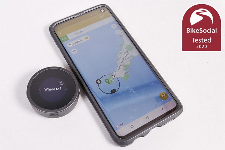
The Beeline moto on review here is an alternative to the usual sat-navs from the likes of TomTom and Garmin – at just 48mm in diameter, it’s a tiny device that sits discretely on your bike to give turn-by-turn navigation, or a simple direction arrow (in ‘compass’ mode), when riding anywhere in the world… as long as your smartphone is connected.
At £149 it’s a much cheaper option than a ‘proper’ sat-nav, but can it compare to the self-contained GPS units available?
Brilliant compass mode encourages exploration of new roads
Very easy route planning with surprising control if you want it
Not a big drain on your phone’s battery
Not as accurate or easy to read as a full-spec sat-nav
Doesn’t warn of speed cameras
Currently doesn’t recognise closed roads
Beeline Moto review: Features and mapping included
Compass Mode simply points out the direction (as the crow would fly) of your destination
Alternatively, a specific route can be automatically or manually planned for turn-by-turn navigation
Uses Google mapping, so coverage is worldwide, and the app can display as a standard map, terrain, satellite or hybrid
No distractions on the screen from phone calls, texts etc – just simple navigation
Scratch-resistant toughened-glass screen and plastic case (metal case costs £50 more)
Universal mounts supplied
Routes ridden can be saved and ridden again
Can also be switched to cycle mode for use on a bicycle
Route planning and navigation is performed by your smartphone – the Beeline acts as the display, so the phone and device must have power at all time
Battery level of device and phone shown on display when app is running – buttons allow flicking between each page of information


Beeline Moto review: Mounting to the bike
This is the standard model, which comes with a cleverly-designed with a grippy backing that straps to your bars or triple clamp with two large pairs of different-sized O-rings.
Also included is a sticky pad and mount – with a removable extension arm – that’s neatly compatible with GoPro brackets. Between these options, I had no problem fitting the device to the Kawasaki Versys 1000 (using the GoPro mount), my Kawasaki ZX-6R (using the strap mount on the fairing stay), and the Royal Enfield Interceptor (using the strap mount on the bars).
There are separate fixings available, including mirror mounts, RAM ball adaptors and bar clamps, or you can choose an additional mount with a bundle pack for £15 more.

When not connected to the app, the Beeline simply displays the time
Beeline Moto review: Set-up and updating
A charging cradle is supplied, powered by any USB supply, as well as a useful printed quick-start guide – as soon as I unplugged the device from the charger, it showed a link to the app and the ID of the device. With the iOS/Android app downloaded (I’m using a Samsung Galaxy S10), the Beeline set itself up and connected. Brilliantly simple and a world-apart from the faff required for larger ‘proper’ sat-navs.
Connection is automatic once set up; the only minor glitch I had was after losing all the Bluetooth settings on my phone – the best way to reconnect the Beeline was to simply unpair it and set it up again (which took less than a minute).


The side buttons allow you to scroll through the pages on the device
Beeline Moto review: Controls
Unlike the Beeline Velo designed specifically for cycling, which has a capacitive touch screen, the Moto version has four physical buttons – the yellow one on the top is for power, the two on either side are for scrolling between pages, and the bottom one is for accessing options. The settings on the device are only for unpairing and for checking the firmware version, but when the app is connected, the two side buttons allow you to flick between navigation, speed, distance to destination and trip, time and trip time, and battery level of the Beeline and your phone. You can also end a route from the Beeline by pressing the power button then confirming with the bottom one.
While there’s not much need to use the buttons, they aren’t very tactile – being quite stiff, they’re pretty hard to press with thick gloves on. A lighter action would have been good, though that may have caused issues with the waterproofing.

Mounted to the Versys 1000 using the included GoPro-compatible mount, I never had any issues with seeing the display
Beeline Moto review: Display layout & clarity
The Beeline uses a ‘transflective LCD with LED backlight’ – basically, it’s like a Kindle display, which means it’s easy to read in daylight, while the backlight will come on automatically (based on the time of day that the app determines it to be needed), or can be switched on manually. It is very easy to read – only when riding direct into sunlight can it get tricky, but no more so than any other display or even your bike’s dash; shielding your eyes (for instance with a peak) cures it.
Using the app, you can easily choose the units you want displayed from the following:
Kilometres
Miles
Miles and feet
Miles and yards
Miles and metres (my choice)
It’s great to find the device so simple and easy to set up – no long lists of options or settings, just the bare minimum for an intuitive system.
The navigation display itself is cleverly compact, but it does take a little getting used to; fortunately there’s a neat tutorial built into the settings on the app.
The main arrow during navigation shows you the direction you should be heading; in Route Mode follow this, and use the white dot to see where on the road the next turn will be coming. The distance also tells you how long it is until the next turn. There’s a progress marker that shows how far you are through your journey, but this doesn’t seem to get much bigger on longer journeys; I’ve not found this feature to be much help.
In Compass Mode the large arrow simply points at the destination, with the distance showing how far it is as the crow flies.
Beeline Moto review: Waterproofing
Both the plastic- and metal-cased Beelines are rated to IP67, which means dust won’t get in, they can survive water jets (great in the rain), and they can be immersed in water up to one metre deep (you’ve probably got bigger problems if your bike’s a metre under water.

Planning a route on the app is easy, but there’s a surprising amount of flexibility to change it
Beeline Moto review: Ease of route planning
Looking at full navigation first, planning a route is incredibly quick and easy – from Peterborough to Lands End is calculated in a couple of seconds. While there’s no option for a ‘winding route’ like you’d find on TomTom and Garmin, you can quickly turn on the option to avoid highways, which gives slightly more scenic routes, and Beeline has something potentially much better to offer, but more on that in a moment...
By default, the app will start route planning from your current location, but by touching the start point, you can drag the arrow to a new place, or touch the ‘current location’ icon on the circle to search for a new point.
With the route planned, you can touch anywhere to add a waypoint, then drag it, or search for a new location. It’s surprisingly powerful when you dig into it, while still very easy to just plan a simple route; it’s worth having a read of the full Beeline user guide here.
You can add a maximum of 22 waypoints to a route; I don’t see this as much of a limitation – if you need to plan a route in more detail you can create it in other software, then upload it as a GPX file; I was able to add a GPX by finding a link online with my phone (like this one of the best motorcycle riding routes in the UK) – once downloaded, I had the option to open it in Beeline. Unfortunately, it’s not possible to export your routes as a GPX for use on other devices – all you can currently do is share the route line overlaid on a background or pic of your choice.
The only limitation I managed to find with GPX import was when trying to install the entire Trans European Trail for the UK – the one file is broken into sections, so while the BMW Motorrad connected app recognised them and gave me the option to save all the sections or individually, Beeline only showed one small section. Realistically, this is a ludicrously large GPX file, and the fact that I was able to successfully import the North Coast 500 GPX to the app shows that it’s more than capable of handling what it’s designed for.
You can also plan a route from scratch simply by touching to add waypoints – up to 23 on top of the start location. Zooming in will give the level of detail needed for densely-populated areas; the only thing I found lacking was an easy way to create a circular route; you can do it, but you need to draw it around and find a location near (but not on top of) your start point, or set a destination, pull out a couple of waypoints, then touch the destination and set it to your start point. It’d be great to see the option to set a destination, then have the app find one route there and another back
You don’t need the device connected to plan a route, and recent searches show up as you type. The auto-fill also works well, and there’s no problem looking for specific places like the Super Sausage Café or Chris Walker Kawasaki, rather than having to find the postcode; something that’s not always that easy on a fully-fledged sat-nav.

The icon under the arrow shows the fork I need to take in the road
Of course, while there’s no winding route option, complaining about that is missing the point of Beeline – turning off ‘Route Mode’ gives you the compass-style navigation that strips all complications out and simply points in the direction of your destination, as the crow flies.
Planning this kind of journey is just a matter of toggling Route Mode once you’ve set your destination. You can still add up to 22 more waypoints, and in this case the device will point at each waypoint until you reach it, or until you press the device’s top button to skip to the next one.
What’s important to understand is that the Beeline is about using road signs; I’ve got lazy through using my TomTom, not taking any notice of road signs or land-marks, simply letting the sat-nav tell me which turn to take next. In Compass Mode, you need toyou’re your common sense, have a vague idea of the destination, and keep an eye on road signs.
As long as you have the time, you can really explore while riding, taking any turn you fancy while meandering your way to your destination…

I used Compass Mode to get to Chris Walker Kawasaki – the grey line is the grey line is as the crow flies, while the blue line is the route I ended up taking
There’s no point in testing the Beeline on a route you know; I had to see if I could trust this device to get me where I wanted without previous knowledge to guide me. To review the Compass Mode, I set Chris Walker Kawasaki as the destination. I’d not been there since they’d moved (and set up a great new café), so all I knew was that it was still in Grantham.
Simply following the arrow didn’t give me that much confidence at first, but I knew some roads I fancied near to home that were in the right direction. As the journey progressed, I’d see roads I liked the look of and would take them, the Beeline always pointing at where my final destination was.
As I got into Grantham, the Beeline managed to steer me right to the front door. Brilliant, and I can’t help admitting I was a little surprised at just how well it had worked. In complex road systems it might take a little longer to find your destination, but Compass Mode is not about getting there quickly; it’s about enjoying the ride.
While it wasn’t the longest route, Beeline turned that trip into a 36-mile journey that took me over two hours on my ZX-6R. I found some great roads while I was at it, and because the app automatically records your journey, you can ride it again if you want, or simply identify the best bits you want to revisit.
If things do get complex – in a city at the end of the journey for instance – it’d be great if you could press a button on the device to have it switch to Route Mode. Currently you can’t do that even in the app, instead needing to stop the current journey and plan a new one, turning Route Mode on this time (though as recent searches show at the top of the list, this takes seconds).

Mounting the Beeline is easy – here I’ve got it on the fairing bracket of my 1999 ZX-6R
Using Route Mode gives you turn by turn navigation, so I used it to take me the 156 miles to Highcliffe in Dorset for a meeting. Covering motorways, A-roads and more minor routes, it was a good chance to see how accurate the Beeline is.
While having the arrow pointing the road direction and the dot showing the next turn generally worked fine, there were a few times during the 3.5 hour journey that I had to back-track. These were usually caused by the fact that the distance reading to each turn can be as much as 20-50m out, which in busier road networks can see you sailing past the junction or in the wrong lane for a turn. The GPS accuracy will of course be influenced by where your phone is (remember the Beeline device doesn’t have its own GPS chip), but I had my Galaxy S10 in my pocket on the way to Dorset, and in the top of my Kawasaki Versys 1000’s top box on the way back.
The display has a neat little icon for roundabouts with the exit number to take inside – this is a little small, but it’s the only part of the device that can be tricky to read; it’s a shame really that all of the 42mm glass isn’t screen; only a diameter of 26mm is used, but it works.
Junctions are shown with an icon that indicates which fork to take and that’s helpful too, though it did glitch once, the icon saying to take the right fork, but the arrow saying left. It was left, so the device knew where the road should go, and to be fair, this kind of thing can happen on full-size sat-navs, but there you have the advantage of a large map and often images of the road layout too, so there’s rarely any doubt.
Another time this lack of visual mapping became an issue was on an unnamed road – my TomTom will often not tell me there’s a turn coming up, but the clear map will show the route I need to take. On the Beeline, you’re relying on a count-down to the next junction, a dot and an arrow. The dot doesn’t show there’s a turn coming up, and there was one time that it just wasn’t clear enough from the arrow which way I should go. Of course, narrow deviations on unnamed roads are few and far between, but it’s another point worth noting to manage expectations of the device, as is the fact that when I did get to Dorset, I rode past my destination’s entrance twice before I realised where the correct turn was.
Finally, the mapping – while great – isn’t always accurate enough. When plotting a route to the Bennetts Peterborough office, the location is found perfectly, but the route takes you to the dual-carriageway beside the office, where there’s no way to get down. Only by dragging the point further way from this road does it re-plot to take you onto the correct route; the final destination can be a little too woolly for some trips, so check carefully when planning, especially if you’re heading somewhere close to a motorway.

Sometimes, the route mapping can deliver you just out of reach of your destination so it’s worth checking before you set off
Beeline Moto review: Finding fuel
Unlike a ‘proper’ sat-nav, there’s no option to touch a button and find the nearest fuel stop. If you’re in the middle of a ride, you’ll need to stop the route, then search for ‘petrol station’, though keep in mind that some might be listed as ‘fuel station’ and others as ‘service station’, so it’s not the easiest way to find the nearest stop.
On my way to Dorset I resorted to Google for fuel, looking at that app’s map to work out where to go, rather than cancel my Beeline route and find the postcode.
I’ve been spoilt by TomTom’s brilliant side-bar, which shows upcoming fuel stations, but remember that Beeline is not trying to replace a fully-fledged sat-nav that does all your thinking for you.
Beeline Moto review: Speed camera notifications
There are no speed camera notifications with Beeline, though as it works around an app, there is the potential to introduce features like this in the future; Beeline tell me that the team is always considering and developing new features based on the needs and desires of its community.

With no live traffic data, it’s possible to get stuck if you’re unlucky, as I found out on the M3
Beeline Moto review: Adapting your route / detours
In Compass Mode, where you go is of course up to you, but in Route Mode, if you run off course the device can automatically redirect you, or it can be left for you to tap the top button to do it manually.
One issue I did come across was a waypoint in Route Mode wasn’t recognised as having been visited (the searched business location had put it on the opposite side of the road to where it was), so after leaving, the Beeline kept trying to redirect me back; the only way to stop this was to pull over, take my phone out and cancel the route before plotting again. It’d be great to be able to skip a waypoint in Route Mode in the same way you can in Compass Mode.
Despite being connected online, and using Google maps as the background, Beeline hasn’t ever been aware of a closed road when plotting – a road near home was recently shut for a week, but the Beeline app didn’t know this. I was also held at a standstill on the M3 while a pot-hole was filled (I’m still not sure why they didn’t close that one lane, rather than the entire road).
I asked Beeline about integrating closed roads and accident data into the app, and was told “We are currently using MapBox for routing at the moment but it's possible that they are not always as up-to-date as Google is on closed roads. We're always reviewing our routing providers and may change this in the future.”

The Beeline is charged using a cradle that picks up on these two pins on the back
Beeline Moto review: Battery life
The 400mAh lithium polymer battery built into the Beeline claims to last up to 30 hours without the backlight, or 10 hours with it. Standby time is four to six months when not in use. In my experience, having used it between the start of February and up until the lockdown began at the end of March, I only had to charge it once; impressive.
While you do of course need to have your phone connected to the device, which will drain its power, it’s not too significant; I got to Dorset while also streaming music to my Sena without running out of power. Because your phone’s screen doesn’t need to be on, the power drain is much reduced compared to using the phone to navigate.

Beeline Moto review: Verdict
The Beeline isn’t a cheap alternative to a full-spec TomTom or Garmin; it doesn’t have the fine level of control, or the very visual navigation and accuracy. If getting somewhere at an exact time with the minimum of fuss is what matters to you, I’d think carefully before choosing this over a ‘proper’ sat-nav (or even using your phone strapped to the bars).
But that’s to have missed the point of the Beeline – this isn’t for when you’re not in a rush, it’s for enjoying a ride and getting back to some of the simplicity of being on a motorcycle. For me, it’s the joy of exploring with the compass mode that really stands out here, but the fact that it’s a discreet, beautifully-styled device also means that it can add a good level of navigation to any bike, without having to spoil it with a large colour screen.
I’d be nervous of relying on the Beeline for big trips in a foreign country, or when I need to be at a meeting on time and be aware of any travel disruption; for those, I’ll still turn to the TomTom. But when I want to just enjoy a ride, to explore new routes while still having a destination in mind, the Beeline really is a great little device that only adds to my enjoyment of motorcycling.