

My choice of top ten routes in the world is based on having spent 40 years travelling overland around the planet on 10 circumnavigations by motorbike and bicycle. Every mile means a different window into something I haven’t seen before or missed the first time around. The best corners I never forget and leaning over closer to the ground I pick up perfume from hedgerows, sometimes smells of sulphur and dung, oil and the sweet smell of diesel evaporating in a warm sun. The release of a long list of volatile compounds and gasses from cut grass sheared by a mower, a rough wind or a sharp frost has a fresh truffle smell known to every biker. Riding a bike has a cinematic experience about it, almost a 3D feel to the way you absorb what you see, smell and feel on the way.
For each map, click on 'More options' to open the map in Google Maps, from where you can download or amend the route.
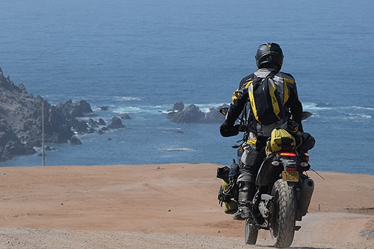
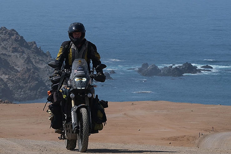
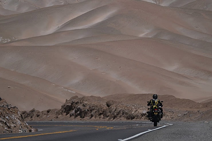
1. Pan American Highway, South Peru
Where does it start?
Nazca, a days ride north of Calama, but the best bits of the coastline are between Calama and Punta de Bombon before going inland to the gentle town of Moquegua.
Where does it end?
Well, the coast route continues onto Tacna on the border with Chile and then on to Arica in Chile. All of the Pan Americana is not consistently thrilling but to be honest it beats 90% of the routes I know for sheer bravura. The Pan Americana (or Pan American Highway) is the longest highway in the world, stretching from Deadhorse in Alaska down to Ushuaia in Argentine’s Tierra del Fuego. This little section however is absolutely one of three bests bits of the whole route and ends at Punta de Bombon in Peru.
How long is it?
Could be about two hundred miles max. I don’t always know, a day’s ride? When you are in highway paradise you get carried away with you place in time and space. You never want the ride to stop.
Why is it great?
The southern Peruvian coastline is without doubt in my mind as being the very finest coastline in the world to ride a motorcycle. Nothing comes close to its beauty. The road dips down to the sea before rising majestically to form high cliffs mixed with sides of sand dunes that are amongst the biggest in the world. Shoulders of mountains from the Altiplano of the Andes descend to the sea and somewhere in all of this geology, engineers have created a riding miracle. Yes, it’s as good as that!
What do I need to know?
The road is newly paved and is excellently surfaced. In the initial period after Nazca, where you have a choice of going inland or remain on the coast, there is hardly any traffic. Can you repair a puncture to a tube, take a wheel out. Can you plug a tyre? No services so you need to know but as I haven’t punctured more than twice in 20 years, you might never need to know, right!
Anything else?
Enough gas stations not to be a concern. Plenty of places to eat in small towns. Perfectly respectable with a choice of eating establishments from which to feed and water. Plenty of hotels in towns on route that are super affordable. There is nothing, not one thing that I could not like about being here.
2. Salar de Uyuni, Bolivia (Salt Flats)


Where does it start?
You point your bike towards what you think might be the middle and try and keep the sun to your bike if you leave at sunrise from the outskirts of Uyuni. You’ll hit the other side eventually and you don’t have to stop at the mountains because there are routes that take you deep into Bolivian backroads. Check out Robin Thomas at www.uyunimotorcycletours.com as he supplies bikes and clothing if you don’t want to get salt into your electrics.
Where does it end?
Depends on what you think is a route. Is it A to B or can it occasionally be a bit more free-forming. This is probably the most unique route in the world. You start one side, ride across then ride back. The experience is so phenomenal you’ll understand what this means only when you’ve done it.
How long is it?
80 miles across.
Why is it great?
Geographically there is nothing like this on this scale anywhere else in the world. When dry it’s a feast not just for what hits you with full panoramic vision, but for the imagination. You look out as far as you can see and all there is before you in every direction are hexagonal imprints of salt crystallisation from evaporating water. Go to the movies and watch Star Wars: The Last Jedi and see a blazing white stretch of salt crust that doesn’t stop until it bumps up to massive mountains that look tiny from where you stand. You’re in that movie.
What do I need to know?
If you lick the salt crust, yes, it really tastes of salt. The solid surface on which you can and are allowed to ride is several metres thick and covers a layer of brine, which is exceptionally rich in lithium where there exists 50-70% of the world’s known reserves.
Anything else?
It’s estimated that the Salar contains 10 billion tonnes of salt of which 25,000 tonnes are extracted annually. Could take a while to mine. It’s so flat and being the largest such geographical feature on earth, it’s ideal for calibrating distance measuring equipment on satellites.
3. Valley of the Rocks, Bolivian Andes


Where does it start?
Mark Uyuni on a map and run a pencil west along the road that you see until you cross the Andes to the small rail-head settlement of Olleague. Continue onto the Chilean town of Calama. Can’t go wrong as there are no major turn-offs.
Where does it end?
Before Calama, it sort of tails off in a not uninteresting straight falling bang in the middle of town by a shopping mall of some considerable size and modernity. Not everyone wants to cross the Andes on a motorbike, preferring instead to shop. Personally, and more interestingly, I’d go a little further south east to the nearby hippie back-packers hang out at San Pedro de Atacama.
How long is it?
A day will do it easily and next time I pass I’ll camp at the summit with my wife and she’ll cook me my tea. Road distance is about 380 miles as the Condor flies from Uyuni to Calama and then San Pedro. If you are holed up with an interesting pillion as I intend to be, it could take considerably longer!
Why is it great?
Some routes have magic signs that say you are in biking heaven and others hit your soul intravenously as you are drip-fed whatever it is that makes you feel extraordinary. This is that place. Clearly by examining why you ride a motorcycle – freedom, sense of self-worth, purpose, get away from the kids / in-laws / people-in-general – take something like a box and tick it, because it is all of this and so much more. Whilst it’s true feelings do come and go like clouds in a windy sky, there is no doubt in my mind that out here when you stand by your bike at this summit of the Andes, in the Valley of the Rocks (a real name), you will feel inspired like never before. Yes, the wind does blow hard with a never-ending supply of clouds rushing across a pin-sharp blue sky. Pitch up your tent. There’s no one around around. Put a brew on and remind yourself that if this is the first and last time you get to be here, soak up every minute. A little fine dining in Uyuni all washed down with excellent coffees and shakes in San Pedro de Atacama (its location is in its name.)
What do I need to know?
How to get there? Ah, that’s the rub. It’s quite a way and this needs another article. If you do get to South America (via Montevideo by ship recommended) or south from Central America (the only way) you’ll find there’s nothing at the top so bring all that you need – tea bags, a few butties, that sort of thing. Further down the western side towards the sea there are one or two isolated eating places serving soup with the possibility of inexpensive and perfectly safe but basic accommodation. At the Bolivian / Chile border, Olleague, you will find hostels with small restaurants and if you stand by the small municipal building in this tiny but smart and super friendly village, you’ll get online. Enjoy the descent, it’s amazing.
Anything else?
Sometimes take a break from smiling as it will make your face ache.
4. Paso de San Francisco, Argentina


Where does it start?
Copiapo in Chile. Ride north on the Pan American Highway and watch for the sign Paso de San Francisco which you’ll see 20 minutes out of town. You turn left, gas up on the corner, take on board some water and a few cans of food and within minutes you are away from everybody on one of the best roads that exists on the planet.
Where does it end?
It ends in a less than interesting but sleepy enough town in Argentina called Fiambala. If you work on the premise that a bad day on the bike is always better than a good day in the office, there are very few bad places through which you need to ride your bike. Less than fascinating it may be but before you shoot across Argentina, at Fiambala there’s gas, cash points and I can recommend a smashing hotel nearby.
How long is it?
I do it in a day but really that’s rushed. The panoply of geological wonderfulness that expresses itself as strata on the side of mountains so high they hold up the sky, is quite simply, awesome.
Why is it great?
You leave a pleasant enough city which has everything a motorcyclist needs to get on the road, including sorting out knackered riders or poorly motorbikes. You have an extremely easy piste which guides you into a pristine mountain wilderness devoid of traffic and people. The air is crisp, and at every turn the extremities of surface furniture are beguiling. Deep ‘v’ shaped stream beds rise up to cliff faces so high you need to strain your neck to see the top. You can camp everywhere and an hour into the ride you will see the only posada nestled into the hills. No name but it’s the only place around for a hundred miles so you won’t miss it. It has cheap accommodation and is one of the most isolated habitations in the world. Oh, the superlatives go on. You wind up to 12,000 ft or so and have the whole pass to yourself. The last time I was there on my Ténéré 700 in 2020, I camped and made myself a super dinner using only a tiny ‘stick-stove’. At the border where you enter Argentina, you are released onto a newly tarmaced two lane highway on the Altiplano, a plain that spreads out between high mountain peaks glistening with the folds and thrusts of copper, salt-peter at dry lake edges, chinchillas dash across the road as you approach and I have seen Condors with their 8ft wingspan.
What do I need to know?
The ‘Tears in Rain’ monologue from the film Blade Runner. Character Roy Batty played by actor Rutger Hauer as he’s dying, “I've seen things you people wouldn't believe. Attack ships on fire off the shoulder of Orion. I watched C-beams glitter in the dark near the Tannhäuser Gate. All those moments will be lost in time, like tears in rain. Time to die.”You know what I’m saying. Do it before you die!
Anything else?
Assuming I don’t fall off and the bike doesn’t break down, are there any obvious problems that could be encountered which might spoil my understanding of what anyone with a brain would consider this a perfect riding day? No.
5. Baja, California, Mexico


Where does it start?
Baja California is a peninsula and in the north it borders the USA so anywhere you enter you have started. Assuming you travel south from equally exciting routes such as Big Sur on the American Pacific seaboard south of San Francisco you will possible enter through Tijuana. Entry is through an automated control booth which takes seconds, requires only a passport and with the necessary use of a GPS system, an otherwise unfathomable traffic system pushing through what seems like unending major construction, soon starts to make sense.
Where does it end?
This route could go all the way to Cabo de San Lucas at the peninsula point, a route I know quite well but for me, the best part is from San Felipe in the north-east then ride south down to the miniscule sized Puerto de San Franscesquito where there is cabin accommodation and a restaurant.
How long is it?
I took two days and to be honest I wished I’d taken longer. Technically it’s around 520 miles, half of which is piste with some sandy sections not suitable for road bikes but could be done.
Why is it great?
From Tijuana via San Felipe on the east coast down to Puerto San Francesquito, traffic became sparser the further south I rode, to the point where in the dirt I rode alone. That has plus and minus points of course, riding alone in dirt could leave you at the mercy of a mishap, mechanical or bodily for hours if not a day or more, but the joy of being alone and feeling you have the peninsula to yourself is beyond exciting. My best routes of the world are extraordinary and make up a few of the many I know and are but a small number amongst those I don’t know. Geographically they are challenging to get to but the rewards are boundless.
The route is dynamic and includes long straight flat stretches of piste that filters though forests of cacti only to turn into a section of mountain that envelopes your senses with dust and dryness the which you have only seen on a Sergio Leone spaghetti western. The quietness will make your heartbeat explode in your head. As you drink some liquids and take in a view of chaparral and desert scrub you are reminded with vigour why you ride a motorcycle in this movie which only you are making.
What do I need to know?
The peninsular ranges of the Californian cordillera run down the centre of the state and effectively carve up the climate, humid and cooler at altitude, cooler Pacific oceanic characteristics of marine fog often settling along the west coast and Mediterranean in the north-west and sheltered east south of the Sonora area. The dry southern climate is further attributed to the effects of the Vizcaino desert especially on the eastern desert plain. You also need to know there are enough gas stations for long fill-ups, hotels par excellence, cabins for hire on the coast and in the cities you do pass plenty of cheap places where you can eat. Mark ‘Coco’s Corner’ in your places to visit and you’ll get free camping and can purchase a hot meal. At Coco’s place (a real person called ‘Coco’) you are somewhere two-thirds down towards my suggested end destination. At Puerto Francesquito you will find $20a night basic accommodation and eat fish in the one restaurant caught the moment you arrive.
Anything else?
I met an ex drugs cartel member from Tijuana who explained to me how this city was once extremely safe, how it lapsed for a while, but is now one of the safest cities in the whole of Mexico. Apart from a busy-ness you associate with large populations, it was perfectly friendly and as I crossed over to San Felipe my fears of becoming prey to drug consultants and their associates faded. Mexico for all the bluster about it being a failed state, decidedly isn’t and became just another country I felt honoured to visit. The key thing is that you don’t pass by these places often, once every few years or just once or even never, so it seems a travesty not to absorb all the beautiful moments that rushing seems to erase. If this sounds like “do as I say and not what I do” that does resonate very strongly with me and my riding history, and yet, even though I know now what I clearly didn’t know all those years ago, it may be something of a surprise but I wouldn’t have changed a thing. I’m slower now and it’s all new and so exciting that I’m revisiting places I passed through so quickly before.


6. Coast of Britain
Where does it start?
Anywhere you like but so long as you can see the sea, you’re pretty close. Choose your direction, anti-clockwise or the opposite way around. Take your pick. Remember, as the author Proust says, that the ‘real voyage of discovery consists not in seeking new landscapes but in having new eyes.’ It’s not really where you go but how you see it.
Where does it end?
Same place you started if you fancy a real adventure.
How long is it?
The mapping authority of the United Kingdom, the Ordnance Survey, records the coastline of the main island as 11,073 miles. This isn’t the full story. The British Cartographic Society says, ‘it depends’. If you add the larger islands and measure at the mean high water mark you get 19,491 miles. If you are fact and figure minded and enjoy more than a dabble with your GPS, for interest check out something called the “coastline paradox” and mull over that. The fractal-like properties of our coast means it has self-similar properties at every scale, so if you use more and more detailed maps, the closer the observer gets to look, the more detail is observed leading to a greater length.
Fear not however…the road distance is considerably less than following the coastline or by footpath. 4625 miles is a good start but my own cycle ride followed by my motorcycle ride of 4802 miles is a reasonable assessment of the distance.
Why is it great?
It’s great because you don’t need a plane or any kind of transport to get you to the start line, which can be anywhere. There’s no place in the UK more than 70 miles from the sea, and then you turn either right of left, north or south and off you go. Take a tent.
What do I need to know?
You can decide whether to follow unclassified roads and really cling to the coast or make little jumps along A-roads to get to the good bits. Where are the good bits? Well, the south coast is a bit hectic but if you go off season into Devon and Cornwall you will discover tiny back roads with little traffic. The Gower Peninsula will take you to beautiful Saundersfoot and then onto the west coast of Wales – pop in for a coffee in my home town of Machynlleth. The west coast of Scotland that encompasses the Scottish 500 is beyond description in its wonderfulness on a good day and the coast of Sutherland a delight.
Anything else?
Yes, you don’t need to be so prescriptive that you stick on it all the time. If you dip in and out of nearby inland towns and villages you are in a wonderland of Britishness in all its eccentric glory and the costs, well, not a lot. Beware of campervans and caravans, they are the bain of Britain.
7. Dalton Highway, Alaska, USA


Where does it start?
The James W. Dalton Highway, usually referred to as the Dalton Highway. It’s a 414-mile road in Alaska that starts north of Fairbanks at the Elliot Highway.
Where does it end?
It ends at Deadhorse near the Arctic Ocean and the Prudhoe Bay Oil Fields.
How long is it?
852 miles
Why is it great?
Why isn’t it great! There is nothing about this route that bores, irritates, annoys or makes you think you’d rather be somewhere else whilst you’re on it. With its vast forests and rivers with nature at its most bold, everywhere you look is BIG. The gravel and dirt road makes for good riding in the dry and is slippery in the wet and sure there are mosquitoes the size of wasps that plague you when you stop, but when you look at a map and you realise exactly where you are on the globe, your heart thumps with pride.
What do I need to know?
There are places to stay at Yukon, by the river and at Coldfoot and Deadhorse. Prices are up there so bring lots of pennies, but there isn’t a landscape in the world quite like the cold desert of northern Alaska.
Anything else?
I’ve been 10 times, when can I go again?
8. Bwlch y Groes in Wales


Also known as the ‘Pass of the Cross’ is the second highest public mountain pass road in Wales. Summiting at 1788ft it is second only to the Gospel Pass in South Wales. Also known as the ‘Hellfire Pass’
Where does it start?
Where the A458 intersects with Mallwyd at the roundabout by the Brigands Inn you need to point your bike towards Dollgellau and filter right down to the pretty village of Dinas Mawddwy. Either ask at the café on the tiny high street thereby engaging with the locals or take the right at the T-junction and go uphill.
Where does it end?
Bottom or top, that is the question:) You climb to the summit or go over to Bala or just before the top take the right fork to Lake Vyrnwy. The pass is more than the sum total of its incline and stupefying views. If, as I do when en route to Manchester, I am in a wonderful world of if you add on Lake Vrynwy…
How long is it?
The southern aspect is 2.7 miles long
Why is it great?
Because there’s a lot of bike history! Before the wars, the British Motorcycle industry was world beating and in 1926, BSA committed themselves to a continual test amounting to 60 ascents of the pass thereby being awarded the ACU’s Maudes Trophy. Between 1933 and 1954 the International Six Days Trial passed over the Bwlch y Groes and its neighbouring roads along the Eunant and Cwm Hirnant.
What do I need to know?
You do not need to go to Scotland if you want to ride a mountain pass. Further correction; you don’t need to ride to the Pyrenees or the Alps either! And, it’s not just about the Pass. Did you know this pass was used in medieval times by pilgrims when they walked from north to south Wales? Neither did I. The cross they erected was replaced in 1989 by the fork to Vyrnwy. If you like birdlife – feathered variety – you’ll see Red Kites, tufted duck, cormorants and mallard. Also the landscape is profuse with upland heather, acid grassland with clumps of ancient woodland and blankets of bog. Pleasing and surprising how many bikers are aware of and enjoy such things.
Anything else?
The southern ascent of the Bwlch y Groes is 1.7 miles long with the steepest gradient being 1 in 4. The old tour of Britain bicycle race known as the Milk Race used the climb throughout the ‘70’s and ‘80’s which took the riders 1150 ft in 2.2 miles. The famous International Six Day motorcycle race often passed up here, notoriously when it was unpaved.


Australia's Highway 1 is a collection of highways that pull together transport links across all state borders as well as joining all mainland state capitals. At a total length of (9,000 miles) it is the longest national highway in the world. It beats the Trans-Canada Highway (4,990 miles) and the Trans-Siberian Highway (6,800 miles). Notably not as long as the Pan American Highway (about 16,000 miles) but this is trans-continental and not therefore a national highway.
HOWEVER, under the original Highway 1 scheme there are a number of important routes that run parallel to this main route and are compiled as “National Route Alternative 1” and this sounds much more interesting, an example of which is the Alternative 1 designation such as the old Princes Highway route from Dandenong to South Melbourne in Victoria.
Where does it start?
Well, either route, Highway 1 or Alternative Highway 1, you would normally start where you flew in but probably Perth or Sydney. Turn left or right and end up back where you started maybe 2 or 3 weeks later (or 2 or 3 months later… why rush!)
Where does it end?
The cryptic answer is “it doesn’t have to end” – depends on the length of your visa, but realistically, see above.
How long is it?
9000 miles plus a bit.
Why is it great?
It’s great because it’s big. Other routes are great because they are not big, or they have other equally redeeming features but if you just want to ride your bike all day every day in a very low volume of traffic where lizards routinely saunter across the road and the most beautiful bush sometimes reaches the edge of the road, how can this not be great!
What do I need to know?
A part of the highway network is traversed by over a million people every day.
So many varieties of life – bowling green culture, tea and cakes along the west coast. More rugged in the north but there is an open air cinema in Broome. Northern Territory culture stands in a category of one – quite wonderfully bonkers. East coast life is busier and hippier.
Anything else?
Remember ALTERNATIVE HIGHWAY 1. Ok, you could do the length of the A5 which starts from Holyhead to somewhere very south in the UK but this has “Grand Epic” all over it. Put your bike on a cargo ship to get there. Ride there. Go and forage, this is a route / trip of a lifetime.
10. Cairo to Khartoum, Egypt / Sudan


What a beautiful couple of countries. Egyptians are incredibly friendly people but there are rather of lot of them in a very confined space stuffed up alongside the banks of the river Nile.
Where does it start?
Well, my starting point is always from home and it will take you a week to get to Cairo overland. There are ferries to Alexandria so maybe you start from there.
Where does it end?
There is now a road running alongside Lake Aswan, I guess there always was but it was prohibited to use it. When I was last there in 2008 I used the ferry which took a couple of nights. Quite delightful. You then dock at the once glamourous port of Wadi Halfa (in the days of BOAC) and head south across the Nubia. There were only tracks into the desert then but I think a road has since been built.
How long is it?
2247 kms, so it says on Google Maps – it took me 10 days. Also there wasn’t a road across the Nubian Desert, I mean nothing, just truck tracks. Should be much easier now.
Why is it great?
If you want a real adventure on a motorcycle you could go no further than this and be totally satisfied. Difficult motoring conditions in Cairo – drivers there are nutters – busy down the Nile Valley for sure but fresh fruit squeezed at every street corner, camels three a breast in small trucks and kind energetic people to help whenever you stop. Forget the politics; think people and you’ll love this ride.
What do I need to know?
Smile, be friendly, stop reading the newspapers and News at Ten and whatever you do don’t believe all the trip that says the world is a horrible place – it isn’t.
Anything else?
Well, if the brief is ‘Great Routes of the World’ then you must expect some of them to be quite far away. It’s only a week’s riding from Europe to the Nubia, but it’s in my living memory when the Dinka tribes amongst others were photographed famously by the German photographer, actress and Nazi sympathiser Leni Riefenstahl. Covering themselves in warm ash from fires sunrise and sunset to deter insect bites is a sight to behold.