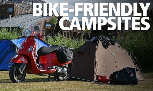
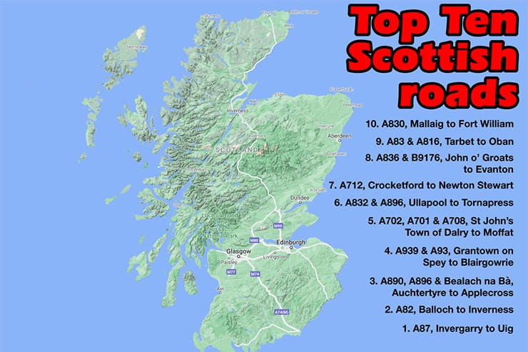
Top Ten Motorcycle Routes in Scotland


BikeSocial Road Tester
22.02.2021


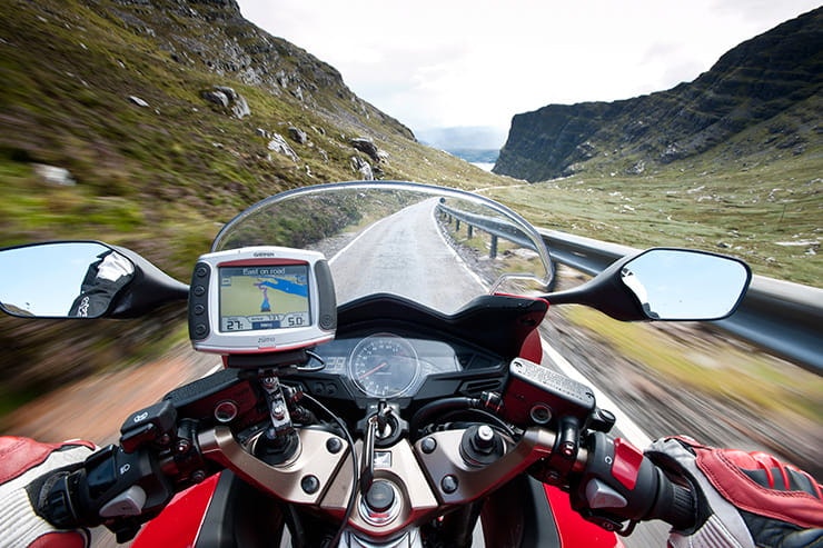

Close your eyes and throw a dart at a map of Scotland, and chances are you’ll hit a great road – either wriggling, vice-like tarmac, scenery from God’s own gallery or, most likely, a combination of both.
Everyone has their own definitions of a great road – for some it’s a wide open, fast and flowing A-road; some prefer tighter corners and more gradient, and some riders like the really squirrelly single-track stuff with humps, bumps, yumps and blind bends. Some like riding at a decent lick picking the right line and some prefer a more leisurely pace, admiring the scenery. And some are two-up on mega-tourers, some solo on sportsbikes. Scotland’s roads cater for it all.
And here’s our top ten (roads or combinations of road) – it’s not a definitive list, so please feel free to add your own contributions and recommendations in the comments module below.


A830, Mallaig to Fort William
Google Maps: goo.gl/maps/dWTpJLnveGPqXp3E9
Distance: 43 miles
Time: 1hr 7m
The A830 – also known as part of the Road To The Isles – is the perfect palate cleanser following a leisurely ride round Skye, ready to head back to the mainland. The Armadale to Mallaig ferry takes 45 minutes to cross from Skye’s southern peninsula and drops you in Mallaig, a small port that was once Europe’s most prodigious supplier of herring. The A830 to Fort William was built in the early 19th century by famed civil engineer Thomas Telford – and judging by its hectic layout, not for nothing was Telford also known as The Colossus of Roads (many other roads in Scotland and north Wales bear his signature).
The A830 is a rider’s road, with good, grainy Scots tarmac and a fabulous well-paced rhythm, with multiple complex bends flowing into one another. But before the good stuff, we recommend a short diversion along the beaches and shoreline on the B8008 (right after crossing the river Morar just outside Mallaig). Then pick up the A830 for the remainder of the ride. The road traces a similar 40-mile path to Fort William as the West Highland railway line, skating south around the mountains overlooking Loch Morar to the north (Scotland’s deepest loch), the rocky northern edge of Loch Nan Uamh and, criss-crossing the rail line, along the north banks of Loch Eilt and Loch Eil before dumping you into Corpach and Fort William.


A83 & A816, Tarbet to Oban
Google Maps: goo.gl/maps/MuXLK2D3gf3EdWYE6
Distance: 85 miles
Time: 2hrs 15m
The biggest problem with riding on the west coast of Scotland is knowing which road to choose – pick one route and you immediately dismiss other classics. Such is the dilemma faced by riders who reach Tarbet, two thirds along the length of Loch Lomond on the A82 north from Glasgow; turn right, staying with the A82, and you get a dazzling run of loch-side bends before Crianlarich, then the increasingly imperious Glen Coe ride, still on the A82 (see further up in the list).
But if you turn left, onto the A83 you’re in for a different kind of ride – less of the epic glacial majesty, more your lush, tree-lined lochs and moderate mountain runs. And the road itself is a sweeping, rushing whoop of delight, lacing small town and villages together as it loops around the head of Loch Long, climbs through Glen Croe, then drops along Glen Kinglas and loops again around the top of Loch Fyne. The A83 then winds south along the west side of Loch Fyne before heading west to Lochgilphead where it meets the A816 north towards Oban.
The A816 carries on in the same vein, passing through low hills and sweeping views out across the Slate Islands, and along the south bank of Loch Melfort into Oban with a steady, rhythmic pulse – it’s a great ride for dialling into the sheer pleasure of smooth A-road momentum rather than stop-start narrow back roads and pulling into passing places to let oncoming motorhomes by.
The town of Oban has settlement roots into prehistory, but the modern town was based around a whiskey distillery and only became significantly populated in the 19th century – today, it’s a bustling ferry port and a centre of tourism.
Out of Oban, the A816 turns into the A85 for the run north up to Connel where it switches to the A828 before reaching Ballachulish Bridge. Here, continuing north beyond Fort William, then Invergarry before heading for Skye, returning to pass through Glen Coe, makes up one of the best routes in Scotland.


A836 & B9176, John o’ Groats to Evanton
Google Maps: goo.gl/maps/irPjeEwZZHGR1gWb8
Distance: 130 miles
Time: 2hrs 50m
The A9 and A99 threading up the eastern side of Scotland’s coastline to John o’ Groats isn’t a bad bit of riding, but it’s a measure of how good the west coast it it’s often seen as a bit of a warm-up act to the real thing. But if, for some reason, you find yourself at JOG and not wanting to complete the full NC500, but don’t fancy just riding back down the A9 again, a diversion along the top of the mainland on the A836 as far as Tongue, then a giddy drop across the heart of Sutherland – still on the A836 – cascading all the way pretty much back to Inverness – is a good alternative. The first part of the A836 through Thurso is fairly unprepossessing, but gets livelier past Raey. Flying past glorious beaches at Melvich, Strathy, Armadale and Bettyhill, stay on the A836 as it unexpectedly turns left off the main road just before Tongue, snaking up into the bleak expanse of mountain wilderness heading south towards Altnaharra – location of the UK’s lowest-ever recorded temperature (-27.5°C on 30th December 1995). The road is narrow and hard work if you’re piloting anything larger than a middleweight; owners of Gold Wings beware. There are plenty of passing places – part of the riding pleasure on these kinds of roads is your skill in timing, so you can slide into and out of a passing place just as traffic arrives in the opposite direction, without breaking your stride. Well, I enjoy it.
After a while the A836 breaks into wide, sprawling conifer plantations, then winds through Lairg and onto Bonar Bridge – where a left fork over just after the bridge gives you a last burst of hilly, moorland crazy on the B9176 before plonking you on the A9 at Evanton, just outside Inverness. The diversion has added only an hour and 30 miles to your journey from John o’ Groats.


A712, Crocketford to Newton Stewart
Google Maps: goo.gl/maps/f4joMzsSSeWFg7hH8
Distance: 33 miles
Time: 1hr
Dumfries and Galloway is something of an overlooked Scottish gem. Stretching from the far side of Moffat in the east, across the M74 and reaching over to the western coastline at Stranraer, the county is nothing if not varied in landscape. The centre of the region is dominated by the Galloway National Park, an area of forests, high moorland and lochs with a special desolate beauty. Through its centre runs the A712.
Like the county as a whole, there’s something for everyone on the A712. Also known as the Queen’s Way for the second half of its length, the road peels off the A75 outside Dumfries at the Galloway Arms Hotel and, for the first four miles it’s an unspectacular but rhythmic roll, twisting lazily through low farmland and dry stone walls. But after Brooklands the first rocks slopes appear and the road starts to writhe with more intensity. The A712 carries on like this, gently entertaining, until It passes through New Galloway where it strikes into the Galloway National Park, the houses and farms stop and the conifer plantations and hillsides begin. It feels like you’ve ridden across a boundary into a different world, as the road widens out and takes on a more dramatic, undulating vibe. The reservoir at Clatteringshaws is a good place to stop and have a brew and a mooch – the dam was built in the 1930s and a road runs up alongside with a great view. Opposite, the Raider’s Road Drive offers something unusual for Scotland (or anywhere, these days): it’s an unpaved road running for ten miles through the forest, and it’s open to two-way traffic, including motorhomes so you can’t go bonkers. But it’s a great chance for adventure bike owners to stand on the pegs for a bit of easy off-roading (but it is very slippery; mind that 19in front on road tyres!).
Back on the A712, another ten miles of forest chicanery await – the final run into Newton Stewart is a flurry of corners and fir trees. There’s much more to discover – the crazy unclassified side road coming off the A714 at Bargrennan and heading up through the north of the park towards Straiton (really) is fabulous entertainment for a lightweight adventure bike. Peel off at the Bell Memorial car park for a special treat!


A832 & A896, Ullapool to Tornapress
Google Maps: goo.gl/maps/1cTHfnPnjezQWaG69
Distance: 100 miles
Time: 2hrs 30m
Part of the NC500’s best bits, the A832 (which actually comes off the A835 trunk road some 12 miles south out of Ullapool) and the A896 that connects with it at Kinlochewe features some of the route’s best riding and scenery.
Just as the going on the A835 starts to get wide open, the A832 turning on the right at big bus stop layby, signposted for Dundonnell, Aultbea and Gairloch, looks like a return to some of the nadgery stuff you might have experienced further back north along the NC500. A lot of riders think the NC is all big, fast, wide open roads, for some reason. Nothing could be further from reality – I’ve seen wider footpaths than parts of the NC500.
The A832 climbs gently at first, with several sections arrow straight, rising and falling like a heartbeat as the tarmac glides over the rugged landscape, chunky crags glowering across a frothing river. Conifers and silver birch groves herald Little Loch Broom, then the A832 crosses the peninsula and, in front, Gruinard Island rises from the sea. The road is still wide and two-lane, threading past Gruinard Beach – stop for photo – and winding along the undulating coastal topography with stunning sweeping views out across the Summer Isles.
As the A832 turns away from the sea, through Poolewe, it narrows and funnels into Gairloch, then turns south alongside Loch Maree and into Kinlochewe. The A896 is a right turn just after the garage, narrowing and running through silver birch groves – with Torridon’s slopes building in the near distance. As you run beneath its flanks, catch the sun dropping behind at the right time and the view is breath taking. The last slim wiggle of tarmac down towards Tornapress gives you glimpses of the famous Bealach na Bà ahead – and that’s another ride in itself!


A702, A701 & A708, St John’s Town of Dalry to Moffat
Google Maps: goo.gl/maps/cntkBDEpmyArKqxn6
Distance: 91 miles
Time: 2hrs 30m
“Don’t tell everyone how good it is round here; they’ll all want a bit of it!” – so goes a common refrain from riders in the know. And their secret? It’s Dumfries and Galloway again, and the roads spilling across the M74 towards the Borders to the east. The epicentre of this region is focussed around Moffat – where, conveniently, you’ll find the Buccleuch Arms Hotel (not to be confused with the hotel of the same name over in Melrose on the A68), possibly one of the most biker-friendly hotels in the country run by the Smith family. Dave, the boss, knows the roads around here like the back of his GS’s tank. If, for some unlikely reason, you can’t find anywhere to ride, he’ll put you on the right track.
The A702, A701 and A708 are proper rider’s roads – the scenery can’t help but be impressive, but the tarmac is the star of the show. The A702 out of St John’s sets the pace immediately, fast and open, opening out over low hills through farmland like a unrolling carpet. Each sweeper blends into the next with graceful ease – there are no tight bends or hairpins to catch you out. In 1990s this is the kind of road would’ve been sensational on an EXUP or early Blade; the mind boggles. These days though, although there are no speed cameras, it’s much more about pace, not speed. You can’t get nicked for riding with ‘pace’, can you?
After Moniaive the A702 calms a little as it momentarily bisects the A76, then picks up again as it heads towards the M74 (okay, the scenery here is seriously impressive). At the motorway, pick up the B7076 south shadowing the M74, for a mile of three, then turn back left when it meets the A701 coming out of Moffat. This is the road around the famous Devil’s Beef Tub – a deep hollow between four hills, where thieves – the ‘Devils’ – hid stolen cattle in the 17th century.
To make the most of the ride, take a sharp left signposted Talla Fruid (it’s easy to miss) and follow the narrow road as it rattles alongside Talla reservoir and up, across and over the hills to Megget reservoir, then down to meet the A708 at Cappercleuch, at the side of St Mary’s Loch. From here, the fast run back down the A708 into Moffat should see your bike stored in a secure shed and you in front of the fire in time for a pint and food at the Buccleuch.


A939 & A93, Grantown on Spey to Blairgowrie
Google Maps: goo.gl/maps/LdoocePAnkCnU8Pz6
Distance: 78 miles
Time: 2hrs 10m
The Cairngorms are a distinct range of mountains, east of the traditional rides around the west coast and defined on the western flanks by the A9 trunk road between Perth and Inverness. But on their eastern side the A939 and A93 are a much more scenic, challenging and exciting ride. Just after crossing the Spey, the A939 picks up the challenge of matching the West Coast’s marvels. It’s a sensational ride, following an old military road laid in the middle of the eighteenth century – swooping bobsleigh-style runs through pine forests, dipping, diving and turning across moorland and mountainsides, hairpins at the Bridge of Brown, a cuppa at the tea-room, then stumble suddenly into Tomintoul – a rigid noughts-and-crosses grid of houses and streets designed by Scottish military nobleman Alexander Gordon, 4th Duke of Gordon, in 1775. Then up past the Lecht ski centre to drop down with scene-stealing views across the eastern side of the Cairngorms. At Gairnshiel Lodge, swoop left onto the B976 and follow the rickety road up and over, cutting the corner off the main, tourist route. Join the A93, past Braemar, and the way starts to rise again up towards the Spittal of Glenshee. It’s one of three roads claiming to be the highest in the UK – at just over 700m above sea level, the temperature in the Cairnwell Pass drops a few degrees as you wind between the peaks. Then the long run down to Blairgowrie starts – the longest, most intense set of whoops, doops, bends and twists this side of motocross track. It’s a riot, so intense there’s no time to contemplate scenery. By the time you roll into Blairgowrie you’ll be ready for a rest.


A890, A896 & Bealach na Bà, Auchtertyre to Applecross
Google Maps: goo.gl/maps/F72A86Dd5vDZCZ719
Distance: 35 miles
Time: 1hr 10m
The distance and time tell the story – 35 miles seems like a short hop, but the wonders on the way will stop you in your tracks (if the hairpins don’t) and the ride can take half a day.
The A890 is a side turning right off the A87, signposted for Lochcarron but easily missed. To start with it’s fairly smooth and wide, but tightens rapidly as it climbs, barely an A-road, rising up and down through conifers and over the top of low hills like a drunken eel. After a splendid view across Loch Carron the road drops down and winds up running along the southern bank of Loch Carron, following the Kyle railway line. It crosses at Strathcarron, then take left onto the A896, doubling back through Lochcarron itself. Take your time through the village – in years gone by a minority of villagers proposed discussing the feasibility of actually banning bikes from the village; an idea overwhelmingly rejected by the rest of the village.
The road climbs out of the village then wiggles, Armco lined, through a narrow valley before emerging at Ardarroch, looking out across Loch Kishorn. As the A896 curves round, the Applecross peninsula appears across the flat river drainage basin at the foot of the mountains. It’s an impressive sight. Take a left the signpost for the Bealach na Bà, warning the road is impassable in wintery conditions, and advising caravans, large vehicles and learner drivers to take an alternative route. Sounds serious.
For the first few miles the Bealach na Bà rises steadily, the rocky walls of the pass growing in spectacle until they tower over the road. By the time you hit the first of several hairpins, the views behind, back down the valley, are truly astounding. As is the gradient – the Bealach na Bà is the steepest climb in the UK, riding from sea level to 2000ft in six miles and hitting 1:5 gradient in places – mostly on the hairpins. A viewpoint at the top lets you spin round and have a proper gander. If the mist has cleared. But wow, what a view. To find anything comparable you’d need to nip over to the Norwegian fjords. Great, jagged creases of granite, strewn with boulders the size of houses, this looks the very essence of a glacial training ground, where ancient gods practiced shaping the planet as if it were made of Play Doh.
The run down to Applecross (apparently that’s not actually the name of the village but it’ll do) is basically a dash to the pub – the Applecross in, geographically disengaged from the rest of the world, is an absolute gem; great food, great hospitality, and rammed with hairy hikers and mad cyclists. Ale, and relax.


A82, Balloch to Inverness
Google Maps: goo.gl/maps/CZs9wot3yvxuDjdq8
Distance: 150 miles
Time: 4hrs
There are two trunk roads to Inverness; the A9 (big, wide, some dual carriageway) carries the bulk of the freight and business traffic – and the A82 handles the tourists (so it gets a bit busy at lunchtime). It starts north of Glasgow but the first few miles are standard getting-out-of-town stuff – then soon, as it runs alongside the western edge of Loch Lomond towards Tarbet, trees and hills take over – there’s something intensely thrilling about the sudden shift in landscape from an urban trudge to big skies, big trees, big rocks and big water, all shrouded in mist.
As the A83 swings right at Tarbet, it narrows into a fiendish series of corners winding under trees following the loch’s edge, then explodes into wide skies again as it nears Crianlarich, all speedy conifer plantations blurring by in a streak of larch green, with the rising topography of Ben More blending brown and purple hues in the background.
Be patient through the average speed cameras towards Tyndrum – refill at the Green Welly – and then the road forks left onto the A85 to Oban or the A82 on the right. Across the Bridge of Orchy, pointy Beinn Dorain looming on the right, round the fast, 180° left hand bend at Achallader, then up the hill – stopping at the top, exposed to the wind, to watch red deer browsing across the heather above the banks of Loch Tulla. Across the high plateau of Rannoch Moor, through a desolate landscape of granite boulders, dark pools and long grass, then into the jaws of Glen Coe, guarded on the left by the hulking shadow of Buachaille Etive Mor.
Glen Coe is around 6 miles long; the A82 winds down from Rannoch between the mountains to the valley floor, the river Glen to the left, passing through the village of Glencoe at the far end of the valley. But ‘valley’ isn’t big enough. Forced apart by the crushing, slithering mass of successive, incomprehensibly vast ice age glaciers, the power of the landscape is in the dizzying height and proximity of the mountains standing shoulder to shoulder, looming ominously to either side like giant, bruised trolls. Cold measurement betrays a glimpse of the scale: the floor of the glen is around 100m above sea level; the peaks to either side rise to almost 1km. Look up either side and you’re staring in bewildered befuddlement at granite presence towering over half a mile high in the sky. It’s as if some ancient Gaelic God hurled a colossal bowling ball into the mountains, smashing a route between them.
The scene overloads the brain; in the same way peering over a tall cliff disorientates and seduces the senses, so looking up at the jagged ridge of Aonach Eagach to the right of the road has you swaying unsteadily on your feet with vertigo. The saw-tooth spine of the mountain cuts sharply against the blueness beyond; the detail of the rocky outcrops and fissures in its vertical sides are rendered with impossible complexity, like a flawless computer animation.
After all that, the run over Ballachulish Bridge and up the side of Loch Linnhe (or is it Loch Eil? I can never tell) to Fort William is a good-natured romp – and the rest of the A82, switching sides to run up the Great Glen alongside Loch Ness on its northern bank into Inverness – is a sweet, easy ride, peppered with villages and touristy places to stop and wander.
Of course, you’re unlikely to make it that far, because just after Spean Bridge on the A82, is Invergarry – and there’s a left turn there you’ll want to make, onto the A87 – because the A87 is the single best road in Scotland.


A87, Invergarry to Uig
Google Maps: goo.gl/maps/ZPBTXaWDt6rozaNd7
Distance: 100 miles
Time: 2hrs 20m
Other roads have better scenery (but not by much) and other roads are better pure riding roads (again, not by much). But if you want the best combination of both, with the added bonus of a decent, 100-mile stretch, then the A87 is the one.
Out of Invergarry, the road climbs uphill twisting through purple heather hillsides and ranks of slender silver birch, glimmering and shivering in the breeze. The dusty grey tarmac – starting to break up in places but still plenty grippy enough to shred tyres – writhes back and forth, trying to catch you out as you sneak looks over your shoulder down across Loch Garry or out towards Lock Loyne. As the A87 crests the ridge it feels high, on top of the world, with striking views across across Loch Loyne to the mountains beyond, and Cluanie Forest. Up here the air, filtered through dazzling sunlight, tastes fresher.
Then the A87 drops down in a blizzard of bends, straightens itself up, and turns left at a T-junction and heads off towards Glen Shiel – a pacey, scenic romp along Loch Cluanie through more mind-mangling mountains that gradually narrow, funnelling down into the village of Shiel Bridge – as the hillside ridges loom, this was where the Battle of Glen Shiel was fought between the English and Scots in 1719 – the Socts supported by a company of 300 Spanish marines. It’s a long way from Spain to come and die on a rocky hillside – and it’s easy to imagine the smell of gunpowder smoke as you pass by.
The A87 speeds along the edge of Loch Duich to Dornie – and to Eilean Donon, a castle standing on a small rocky outcrop in Loch Alsh, where Highlander was filmed 35 years ago, in 1986. Was it really that long ago? You can almost hear the clash of swords as Sean Connery wrestles with Christopher Lambert’s accent (it’s also where a contingent of the Spanish marines holed-up, before the castle was obliterated by English warships anchored in the loch – the castle was in ruins until it was rebuilt in 1919).
Onwards on the A87, the run into Kyle of Lochalsh, over the Skye Bridge onto the Isle of Skye – and away north into the island skirting Loch na Cairidh looking across to Scalpay, and dropping along the edge of Loch Ainort, then Loch Sligachan. The road then winds and climbs towards Portree, the capital of Skye, ending up in Uig, a small harbour with ferries to the Hebrides. There’s a lot to see and do here – Skye has a wealth of exploring, from the Old Man of Storr to the crazy landslip landscape of the Quiraing. The best thing about taking the A87 to Skye is the chance to ride the A830 from Mallaig once you’re done – and which, conveniently enough, is where we came in…