The UK has a huge amount to offer, but if you fancy venturing further afield then here are ten motorcycle trips in Europe that might be of interest. Obviously, the list isn’t exhaustive, but should offer some idea as to great directions and destinations to consider. The main thing to remember is that, while it can be nerve wracking, riding in Europe is little different to the UK – once you get the hang of being on the other side of the road and not being able to speak the lingo. Take your time, and don’t give yourself unreasonable time frames or distances to cover. Above all though… enjoy the ride!
1. The Iceland Ring Road
Where does it start? Reykjavik
Where does it end? Reykjavik
How long is it? 828 miles
Why’s it great?
The ring road of Iceland is by no means the best route on the island, but it does serve as a great jump off point for exploring the more interesting corners of the island.
What do I need to know?
Getting to Iceland is the tricky part. You can either take the two-day ferry from the top of Denmark (about a 1000 mile run from the UK) or ship your bike with Eimskip out of Immingham and fly in to meet it. Both options cost roughly the same at around £1000 by the time you’ve paid for either the flights if you’re shipping in, or the travelling costs through Europe if you’re taking the ferry. Not cheap, granted, but then bike rental is on the expensive side, with costs of around 250 Euros per day, which might make sense if you’re there for less than seven days.
Anything else?
Be prepared for poor weather even in summer; it can be a bleak place. Prices are high, especially for restaurant meals, alcohol and hotels, but if you’re camping and stove cooking it shouldn’t cost you any more than travelling to mainland Europe. The roads are surprisingly well surfaced, with the unpaved F roads heading into more remote, challenging places that are perfect for trail bike riders. But even a Harley could make a good fist of touring Iceland. For more information read the full BikeSocial report here.
Download the GPX file of this route for your TomTom or Garmin SatNav by clicking here
2. Trans European Trail
Where does it start? Wherever you like
Where does it end? Wherever you finish
How long is it? 21,000 miles
Why is it great?
A hugely ambitious project – initiated by Brit John Ross – to map a largely unpaved route from the top to the bottom of Europe, and from the East to the West. The route map is free to download and should keep people entertained for years.
What do I need to know?
As well as through the UK, the TET passes through 27 other countries, including the Scandinavian countries - Norway, Sweden and Denmark, the southern Mediterranean nations of Spain, Greece and Italy, the Eastern European countries of Poland, Romania and Serbia, as well as France, Germany and Belgium. The route spends as much time away from tarmac as possible, though there are linking paved sections taking you from one trail to another. The Scandinavian countries seem to have miles of easy forestry trails, with Portugal and Spain also offering plenty of variety.
Anything else?
Bike choice is a big factor and while plenty of the TET is accessible to large capacity adventure machines, a lot comes down to skill level and tyre choice. A lighter trail bike might make life easier, and even look at the possibility of renting a machine out there, enabling you to maximise your holiday time on the trails, rather than ploughing through Europe to get there.
The Facebook group is a great place for picking up advice for local riders.
To download the maps and to find out more visit www.transeurotrail.org
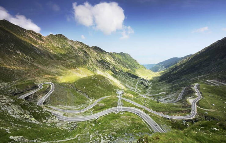
3. The Transfăgărășan Highway
Where does it start? Bascov
Where does it end? Sibiu
How long is it? 56 miles
Why is it great?
An obvious suggestion ever since Top Gear featured it a few years back, the road definitely carries some romance and gives good reason to push east out of western Europe.
What do I need to know?
The road is 56 miles in length and crosses the southern section of the Carpathian Mountains. It’s located approximately 130 miles west of the Romanian capital Bucharest, and almost 1500 miles east of Dover, meaning that it’s going to need a couple of weeks to get out there and back. The advice, if you do go, is to get there early as traffic can be dense.
Anything else?
Check the road is open before heading out. Generally, it’s closed from mid-October to early June due to snow, so the window is short. In a way the road would arguably best serve as a marker for a wider trip, with good excuse for finding an interesting route for getting down there and back. A route down through the Balkan countries of Slovenia, Bosnia and Herzegovina, and Serbia is increasingly popular with bikers, while a route back through the Alps would give you the best of both worlds.
But so much depends on how much time you have. If you’re racing to get down there and racing to get back, then maybe consider an interesting road a little closer to home. Good information can be found here.

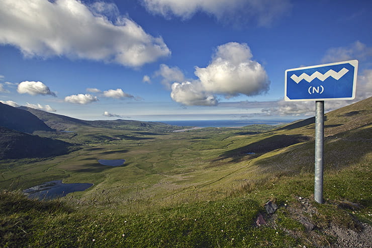
4. The Wild Atlantic Way
Where does it start? Kinsale, County Cork
Where does it end? Londonderry
How long is it? 1553 miles
Why is it great?
Officially the longest coastal route in the world, and with inexpensive ferries from the Welsh ports of either Fishguard or Holyhead, the Wild Atlantic Way is a dream destination for those with limited time or looking for adventure a little closer to home.
What do I need to know?
It’s not so much a point-to-point route, more a theme of travel along the coastline of Ireland, covering a total distance of 1553 miles and passing through nine counties and three provinces. The tourist board designates six regions of the route; Northern Headlands, Surf Coast, Bay Coast, Cliff Coast, Southern Peninsulas and Haven Coast, with the Southern Peninsula likely to be increasingly popular as it’s just off shore that Great Skellig – the island featured in the latest Star Wars movies, The Force Awakens and The Last Jedi – can be found, with boats from the mainland able to take you there.
Anything else?
Prepare for rain and be realistic about distances. Those narrow country lanes take a lot longer to navigate than a regular A-road, so 150 miles a day might be the top end of what’s manageable. To plan a route or to find out more head to the official site at www.wildatlanticway.com
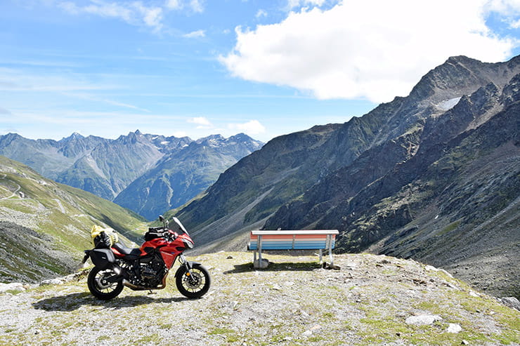
5. The Three Passes of Switzerland
Where does it start? Andermatt
Where does end? Andermatt
How long is it? 80 miles
Why is it great?
An easy to navigate route that takes in three amazing Alpine passes with the full route do-able in a day.
What do I need to know?
The three passes of Susten, Furka and Grimsel are in the Alpine region of Switzerland, crossing the Bernese Alps at an elevation above 2000 metres. The passes are generally closed between October and May due to show.
The Grimsel is a personal favourite due to the multiple well-surfaced switchbacks on the way up, heading clockwise, with emerald blue lakes on the way down. The Furka Pass is higher, at a peak of 2429 metres, and arguably tighter and not as well surfaced, but still an excellent riding road, as is Susten.
Anything else?
The small Alpine town of Andermatt is a good place to base yourself, with all the facilities and some great riding east of there if you wish to venture further into Switzerland. Be wary of Switzerland’s strict speed limits and try not to get carried away; fines are harsh. Also be wary of busy weekend traffic, and as with all foreign riding, try to keep within your own limits and enjoy the scenery. If you have the time then the Nufenen Pass, just to the south of the loop, is also worth riding.
Time wise, if you push straight through France it is easily possible to do this loop and be back home again in a week.
Download the GPX file of this route for your TomTom or Garmin SatNav by clicking here
6. Verdon Gorge
Where does it start? Moustiers-Sainte-Marie
Where does it end? Moustiers-Sainte-Marie
How long is it? 56 miles
Why is it great?
The Verdon Gorge is a magnificent site in itself – Europe’s Grand Canyon – and the roads around it match it for excitement. The coastal resorts of Nice and Monaco aren’t far away either.
What do I need to know?
The Verdon Gorge is down in the south of France, just to the north of Nice and Monaco. It’s 25 kilometres in length and 700 metres deep, and was formed by the Verdon River. Much like most canyons, it creeps up on you; one minute the land is flat, the next minute you’re at the rim of a huge canyon. The road around it is what you’re going for, with endless twisting sections and parts where it traces right across the top of the rim, a steel barrier the only thing stopping you from a long drop to the bottom.
Great riding, great scenery, great weather. And if you want to explore the gorge further then venture along D23, an interior road (broken tarmac in the main) that drops south from the town of La Palud-sur-Verdon on the north side of the rim. Camping is a good option for accommodation in this region, with campsites plentiful.
Anything else?
As with any popular tourist place, traffic can be an issue in peak season, but at least unlike the Alpine passes listed above, you can ride the Verdon Gorge most of the year, so aim for the shoulder season of spring or autumn and you’ll be fine. Riding clockwise is recommended for the novice rider as you’re not as exposed to the drops, and if you don’t fancy riding all the way down to the South of France, consider using www.bikeshuttle.co.uk, who can freight your bike down to Toulouse while your fly. It still leaves a 300 mile ride to the Gorge, but that might be a better option than riding from your home in the UK, especially if time is a factor.
Download the GPX file of this route for your TomTom or Garmin SatNav by clicking here
7. The Normandy Beaches
Where does it start? Rouen
Where does it end? Mont Saint-Michael
How long is it? 340 miles
Why is it great?
Good riding as well as the historical element makes for an easily accessible overseas road trip.
What do I need to know?
This coastline of France has long held significance in the minds of British visitors. It’s also easy to access and doesn’t feel that far from home, so for the novice overseas explorer it’s not going to be as intimidating as heading out to the Alps for example.
The route starts in the Normandy capital of Rouen, where you’ll find lots of history dating back to medieval times, before heading towards the Normandy Beaches, and passing through Caen where you’ll find a selection of war museums at the old castle. Then you have the beaches; Omaha Beach with cliffs riddled with German bunkers, Juno Beach where the Canadians came ashore, Utah Beach led by the US 4th infantry, Gold Beach at Arromanches – where the British 50th Infantry Division landed – and Sword Beach on the left flank, where the 6th Airborne Division landed.
The war graves of the Bayeux War Cemetery, Normandy American Cemetery and Memorial, Ranville, Beny-sur-Mer Canadian War Cemetery and the La Cambe German War Cemetery can also all be visited in this area.
The route finally concludes with the stunning medieval monastery at Mont Saint-Michael. The Brittany ferries website – a great option for getting over there – has a superb guide to the region at www.brittany-ferries.co.uk/d-day-guide
Anything Else?
The cheapest way of getting there is via the Dover-Calais route, but for more convenience consider sailing from Portsmouth to either Le Havre, Caen or Cherbourg, which can also be reached via a ferry from Poole. Take one of these options and you could make a good tour of it even in the time frame of a long weekend. For more information on Normandy visit the tourist board website.
Download the GPX file of this route for your TomTom or Garmin SatNav by clicking here
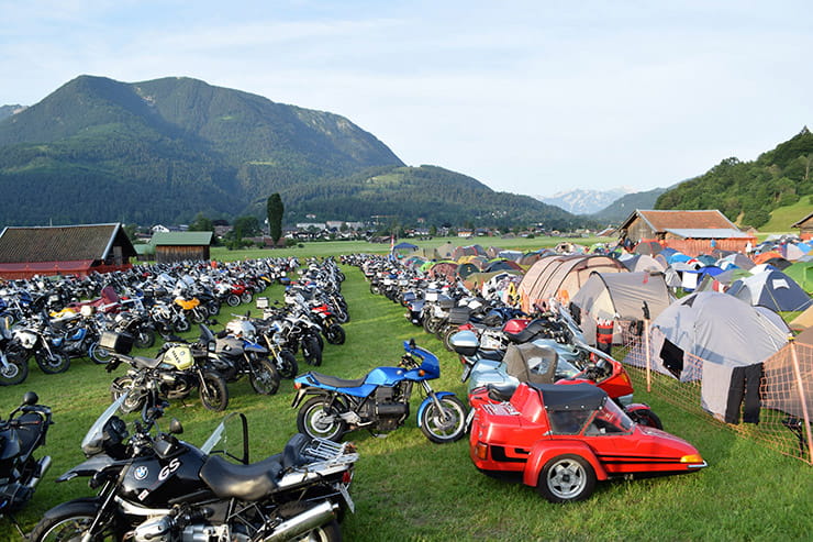
8. The Garmisch Run
Where does it start? Calais, France
Where does it end? Garmisch, Germany
How long is it? 715 miles
Why is it great?
Garmisch-Partenkirchen is a town in southern Bavaria that every year plays host to the biggest BMW gathering in the world (it’s also open to riders of any bike) – it’s well worth heading down to. This is a scenic way of getting there.
What do I need to know?
For 2018 the event is from 6th to 8th July, with this route taking three days to get down there at a leisurely pace, with time to enjoy some stop-offs on the way. You can do the ride back via motorways in a day if needs be, but it’s best if you have time to make an interesting round-trip of it.
From Calais take the A26/E7 all the way down to junction 9 near Bonavis. From there follow the 644 to Le Catelet, then the D28 to the D960 all the way to Vernis.
From there, the D966 to Montcornet, D946 to Vouziers, D982 to Sainte-Menehould, then A4 and finally D904 and D3 down to Port-a-Mousson for the first night’s stop. You’ll find a good choice of hotels here.
On the second day, head across country on the D913 and D955 to the N4, aiming for Baden-Baden. South from here begins the famous B500 through the Black Forest, aiming for somewhere around the town of Schluchsee, 105 miles to the south of Baden-Baden. Be mindful that the B500 can be busy with tourist traffic and police.
The final day (and to be honest you could shorten this run down to two days if you got cracking) is east along the German/Austrian border, aiming for Friedrichshafen on the shores of Lake Constance. The 308 east from there takes you to the 199 and briefly into Austria, before returning to Germany on the 187 where you’ll soon arrive in Garmisch.
You can find route maps here:
Day One: https://www.motogoloco.com/map/?route=9955
Day Two: https://www.motogoloco.com/map/?route=9956
Day Three: https://www.motogoloco.com/map?route=9957
Anything Else?
Book early if you want accommodation in the town during the event as it gets busy with tens of thousands of bikers over the weekend. It is something of a spectacle, even for those not interested in the BMW brand. The food and drink are good, and there’s free camping in the meadows beneath the ski mountains. The event itself is also free to attend – a great excuse for a road trip.
9. The Alpine Loop, including Stelvio
Where does it start? Garmisch
Where does it end? Garmisch
How long is it? 200 miles
Why is it great?
If you’ve made it down to Garmisch, this is a fine route for exploring some of the best mountain roads through the Alps.
What do I need to know?
Heading clockwise, this route takes you on two good passes of Stelvio and the excellent Timmelsjoch that connects the Ötztal valley in the Austrian state of Tyrol to the Passeier Valley in the Italian province of South Tyrol.
On the Italian side, the road to reach the summit is called SS44bis, and on the Austrian side, there’s a toll road, called Timmelsjoch Hochalpenstrasse. From Garmisch take the E533 down to the A12, then 186 south to the ski resort of Sölden (or Soelden) and the start of the Timmelsjoch. Sölden is an upmarket resort with some camping options.
The Ötztal Glacier Road up from Sölden to the glacier (and back) is also a must-ride, with a nominal toll charge mid-way up. From there south along the Timmelsjoch, with a single journey by motorcycle costing 14 Euros, but well worth it, with 38 kilometres of twisting Alpine road that’s well-surfaced and well-sighted. From there take the SS44 leading to Merano, west on the SS38 with a left turn leading to the famous Stelvio Pass.
The Stelvio is maybe a touch over-rated, but it’s still worth riding. It’s quite busy and narrow in places, but worth it for the experience. The town of Bormio at the bottom has good facilities, while onto Livingo has you pointing north, back towards Garmisch, with the SS41 east to the SS40 running north, before figuring your way back to Garmisch, or simply heading back from the foot of the Stelvio heading west to where you could link up with the Furka-Susten-Grimsel Pass listed earlier.
Anything else?
While it takes effort to get through France to the Alps, it is worth it, though try not to rush it and look for ways of avoiding the monotony of the motorways where possible.
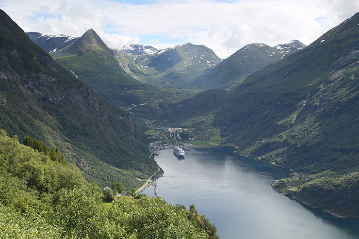
10. The Road to the Fjords
Where does it start? Bergen
Where does it end? Kristiansand
How long is it? 273 miles
Why is it great?
This is a road trip in itself – up along the coast of Norway – but the best bit is that upon reaching Bergen, a world of opportunity opens up for exploring the famous Norwegian fjords.
What do I need to know?
This route begins in the port town of Kristiansand, which can be reached by catching a ferry from Hirtshals at the top of Denmark. This is a two-hour ferry, operated by either Color Line or Fjord Line, with multiple sailings throughout the day and costs around £90 return.
There’s no easy way of reaching the top of Denmark to begin with – not since DFDS stopped its route from the UK to Denmark back in 2014. Harwich to the Hook of Holland is about the best you’ll get, with a 650mile slog to Hirtshals from there.
Once in Norway, the route is easy to follow along the E39, winding along the coast, passing through tunnels and with short ferry crossings between the longer stretches. Once you’ve reached Bergen the options are endless for exploring the Fjords, all of which are no more than a day’s ride away, including Hardangerfjord and Aurlandsfjorden. Or park the bike and take a boat ride.
Anything else?
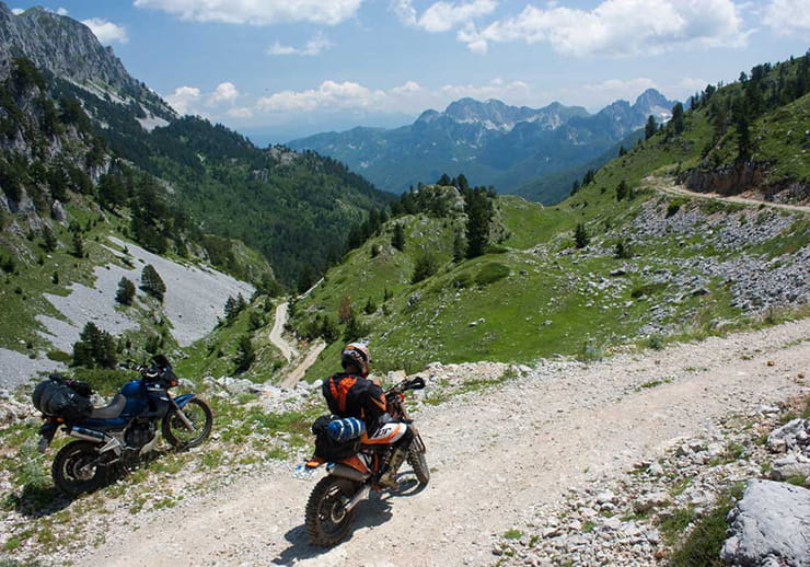
Norway is a surprisingly easy country to explore, with good road conditions, plentiful camping and lodging facilities and a well-established tourist network. Some push onto Nordkapp at the very top, but without doing that extra huge distance, there’s plenty to be seen in South and Central Norway, with it easy to bolt on a side tour through Sweden. If you’re into your trail riding, consider combining it with parts of the TET listed above.
Photo by Brent Leport
Do I need travel insurance?
Just like any holiday, a trip on a motorcycle – be it in the UK, Europe or beyond – can be ruined by delays, lost documents, illness and more. There are plenty of travel insurance options, but you need to make sure you get a policy that includes riding motorcycles, and if it does, that it's for bikes of the engine size you'll be riding (many only cover up to 250cc). At its most basic, you should look for insurance that provides cover for the following:
- Medical expenses
- Loss or theft of personal possessions
- Lost or delayed luggage
- Loss of your passport and other documents
- Travel delays and disruptions
- Having to cut your holiday short
In addition though, if you’re taking a motorcycle (or you're renting one while you’re away) be sure that your insurer will cover you for any medical expenses, should you have an accident. You must also think about where you’re riding – some policies won’t cover you if you’re trail or enduro riding, or if you’re on a race track. Remember – this isn’t about your bike being covered, it’s about your medical expenses, should the worst happen.
If you're only going away once, a single-trip policy will likely be all you need, but also consider an annual policy, which could extend to cover your family holidays too (a good insurer should also be able to offer cover for your whole family).
BikeSocial’s parent company, Bennetts, has a motorcycle-specific travel insurance policy – find out if it suits your needs by clicking here.